|
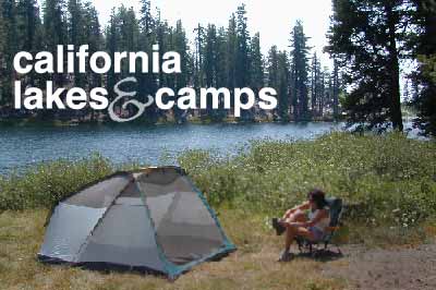
 seeking cool
Swelter no more!
We have the cure, but you provide transportation & the picnic
lunch.
Water & Elevation = Greenery & Coolness
As summer comes to a close, and school starts soon, we in
California know that the worst is yet to come. August thru October
are the hottest months & not to mention wildfire season is
in full swing.
 If
you are baking at 90+ degrees daily in your smoggy city, air
condition buildings become a blesssing. Forget putting down the
top on the convertible. You are in desperate need of cooler temps
& shade. Head to the mountains for fresh air on your day off, real relaxation and a splash in a creek. Camp among towering pines & lay around in a hammock. Tall redwoods, cool ocean air.
If
you are baking at 90+ degrees daily in your smoggy city, air
condition buildings become a blesssing. Forget putting down the
top on the convertible. You are in desperate need of cooler temps
& shade. Head to the mountains for fresh air on your day off, real relaxation and a splash in a creek. Camp among towering pines & lay around in a hammock. Tall redwoods, cool ocean air.
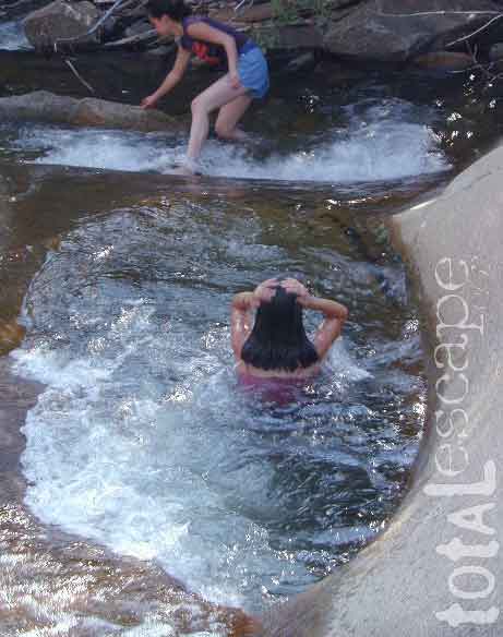
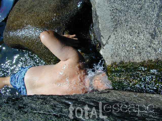
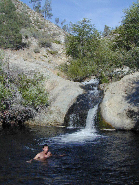
If you are heading to the magnificant Sierra's make sure you
grab a National Forest Map . This will save your butt if you are looking for a private creekside camp or that bitchen little waterfall to play in.
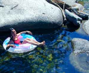
calif swimming holes
|
Plan a day hike to a 10,000' peak. The air is thinner &
breezy up there. Getting caught in a thunderstorm can be a fun
surprise, but remember not to be up on a peak, ridgeline or tall ledge w/ lightning possible. If you hear any thunder nearby chances are there is a lighting strike somewhere, so know your terrain and pay attention. Find emergency shelter under rock overhangs. Pack an extra set of dry clothes.
Drive - Way back there! In order to get the best swimming
holes & secluded waterfalls, you will have to drive further
down the back roads than most tourists. Look at your forest maps, find a stream crossing near a dirt road & head
out to it. Spend the whole day! The farther back you go the more
pristine it will get. Less people, less trash & more opportunity
to skinny dip. Remember, if you are planning the daily bath in
a lake or creek, do not put any soap in the water. The fish downstream
don't like it! See more Camp
Rules
.
|
DON'T FORGET THESE ITEMS:
- towels
- swim suits
- sandals
- hiking shoes
- sun hat
- sunscreen
- bug repellant
- inflatable toys
- air pump /inflator
- old blankets
- extra clothes
- jacket & hat
- hammock
- topo maps
- fishing gear
- camping gear
- food & beverages
|
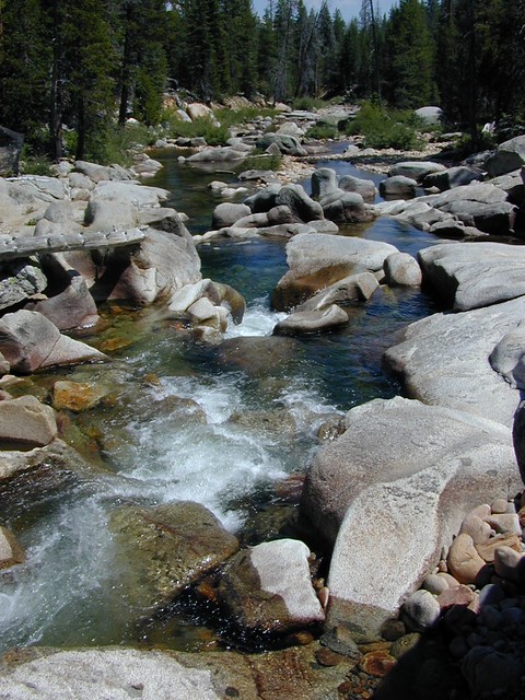
the sierras:
The word Sierra conjures up all kinds of pleasant thoughts. From
great vistas to granite cliffs. Raging rivers, waterfalls &
alpine lakes. We are so lucky to have this huge mountain range
so close to us. Sierra Nevada has the largest trees on the planet,
not to mention some of most visited National
Parks
on earth. But let's not forget the lesser know National Forests.
Backpackers will enjoy the thousand of miles of true Wilderness
which lie protected from roads & traffic. Below are just
a few of the many places to find higher elevations, shady trees
to hang your hammock & an abundance of refreshing streams
& lakes.
| park / forest
|
recreation
|
town
|
hwy
|
lodging
|
| El Dorado NF
|
American River
Consumnes River
creeks, waterfalls
|
Auburn
Placerville
|
Hwy. 49
|
Auburn
Loon Lake Chalet
Placerville
|
| Mountain Home SF
|
Tule River
creeks, ponds,
waterfalls, bike
|
Springville
|
Hwy.
190
|
Camp Nelson
Springville
|
| Inyo NF
|
lakes,
creeks,
waterfalls, hike, backpack
|
Bishop
June Lake
Lee
Vining
Mammoth
|
Hwy. 395
|
Bishop
June Lake
Lee Vining
|
| Kings Canyon NP
|
Kings
River
waterfalls, creeks
backpack, hike
|
Visalia
Hume Lake
|
Hwy.
180
|
Grant Grove
Visalia
|
| Plumas NF
|
Feather
River
creeks, fishing, bike
|
Sierra City
|
Hwy. 49
|
Downieville
Sierra City
|
| Sequoia NF
|
Kern River
creeks, ponds,
waterfalls, hike, bike
|
Kernville
Springville
|
Hwy. 178
|
Camp Nelson
Kernville
Springville
|
| Sequoia NP
|
Kaweah River
waterfalls, backpk
|
Visalia
|
Hwy. 198
|
Giant Forest
Grant Grove
Visalia
|
| Sierra NF
|
Dinkey
Creek
fishing, lakes
waterfalls, hike, bike
|
Huntington Lake
Shaver
Lake
|
Hwy.
190
|
Huntington Lake
Shaver Lake
|
| Stanislaus NF
|
Tuolumne
River
creeks, lakes
|
Groveland
Murphy's
Sonora
|
Hwy. 120
|
Groveland
Sonora
Twain Harte
|
| Toiyabe NF
|
creeks,
lakes,
hike, bike, backpack
|
Bridgeport
Twin Lakes
|
Hwy. 395
|
Bridgeport
Mount Charleston
|
| Yosemite NP
|
Tule
River
creeks, ponds,
waterfalls
|
Oakhurst
|
Hwy. 120
|
Fish Camp
Oakhurst
|
the coast:
NorthEast of the Owens Valley/Bishop area lies the Ancient Bristlecone
Pine Trees. This park gets over looked my many heading to the
western Sierra's to get their tree fix. While Mammoth Mtn is
a huge tourist destination, the White Mountains have the nights
skies, aspen groves & seclusion you may be looking for.
| beach / forest
|
recreation |
town |
hwy |
lodging |
| Andrew Molera SP
|
hike, beach
tidepools
|
Big Sur
|
Hwy. 1 |
Big Sur
|
| Los Paders NF
|
hike, bike,
golf
Lake Casitas
backpack, motorcyles
|
Big Sur N
Frazier Park
S
Ojai
|
Hwy.
101
|
Big Sur
Ojai
Pine Mountain
|
| Montana de Oro
SP
|
hike, bike,
tidepools
|
Morro Bay
|
Hwy. 1 |
Cayucos
Morro Bay
|
| Morro Bay SP
|
hike, golf,
kayak, fish
|
Morro Bay
|
Hwy. 1 |
Cayucos
Morro Bay
|
| All Redwood Parks
|
hike, picnic
backpacking
|
Ben Lomond
Eureka
Garberville
|
Hwy.
101
|
Eureka
Ferndale
Garberville
|
northern cal:
A good amount of Southern Californians think that San Francisco
is Northern California. Hmm, let's see. If you look at a state
map a good one-third of the state lies above the populated Bay
Area. A large percentage of the top portion of this golden state
is covered with trees, lakes, wineries, farms & ranches.
Very rural, very scenic & very little crowds. Sure the coastal
areas will have the summertime rush, but in general, Northern
California has a lot to offer the camper seeking peace &
quiet. Reservations at Campgrounds? - Unheardof! If it's fun,
excitement & recreation you desire, the dozens of pine tree
lines lakes offer watercraft & houseboat rentals. River rafting
is common & fishing is a very popular local past time.
| park
/ forest
|
recreation |
town |
hwy |
lodging |
|
Burney Falls
|
Lake, swim,
fishing, boat
|
Burney
|
Hwy. 299 |
Burney
Fall River Mills
|
| Klamath NF
|
Klamath River
Lakes, fishing
|
Happy
Camp
Yreka
|
Hwy. 96 |
Happy
Camp
Yreka
|
| Lassen NP
|
Lakes, swim,
fish, kayak, hike, backpack
|
Burney
Chester
|
Hwy. 89 |
Burney
Chester
|
| Lassen NF
|
Feather River,
Lakes, fishing, kayak, caves
|
Burney
Chester
|
Hwy.
89
|
Burney
Chester
Fall River Mills
|
| Modoc NF
|
hike, bike,
fish
|
Alturas
|
Hwy.
395
|
Alturas |
| Plumas NF
|
Feather
River
creeks, fishing, bike
|
Sierra City
|
Hwy. 49
|
Downieville
Sierra City
|
| Shasta Trinity NF
|
Trinity River,
Lakes, fishing, kayak
|
Mt.
Shasta
Weaverville
|
Hwy.
3
|
McCloud
Mt. Shasta
Weaverville
|
| Six River NF
|
a bunch-o-
Rivers, Lakes, fishing, kayak
|
Chester
|
Hwy. 96 |
Some's Bar
Happy Camp
|
| All Redwood Parks
|
hike, picnic
backpacking
|
Ben Lomond
Eureka
Garberville
|
Hwy.
101
|
Eureka
Ferndale
Garberville
|
socal:
In order to have these nice temperatures, you must have water...
Rain & a good amount of it. SoCal gets an average preciptitation
of 10 inches per year (if lucky). The past few decades have exeperienced
drought like conditions & water consevation efforts are always
in effect. There is a limited amount of lakes & reservoirs,
few if any real rivers, seasonal streams that dry up by mid-summer.
Basically, the little amount of water recreational areas are
very popular & crowded on weekends - be warned.
| park / forest
|
recreation |
town
|
hwy |
lodging |
| Angeles NF
|
hike,
bike, backpack, motorcyles
|
Wrightwood
|
Hwy. 101
|
Wrightwood
|
| Los Paders NF
|
hike,
bike, golf
backpack, motorcyles
|
Frazier Park
Ojai
|
Hwy. 33
|
New Cuyama
Ojai
Pine Mountain
|
| Malibu
Creek SP
|
hike,
beach
|
Malibu
|
Hwy. 1
|
Malibu
|
| San Bernardino NF
|
hike, picnic, fish
lakes, kayak, boat
|
Big Bear
Lake
Arrowhead
|
Hwy. 38 |
Big Bear
Forest Falls
Lake Arrowhead
|
|