Agua Tibia Wilderness Area
|
& SAN DIEGO COUNTY border |
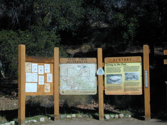
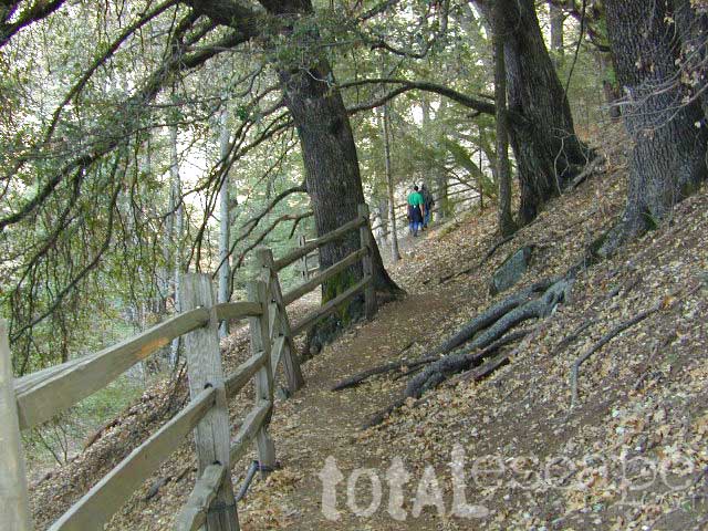
This is the trailhead for Agua Tibia Wilderness located at Dripping Springs Campground on Highway 79, near Temecula CA.
See more: Agua Tibia Mountain hike details


|
& SAN DIEGO COUNTY border |
This is the trailhead for Agua Tibia Wilderness located at Dripping Springs Campground on Highway 79, near Temecula CA.
See more: Agua Tibia Mountain hike details
Atwell Mill is near the East Fork of the Kaweah River, situated in an old logged sequoia grove with the southern Sequoia National Parks impressive Mineral King Canyon. Located 19 mi from Highway 198 near Three Rivers, CA. About 1 mi West of Silver City and 6 miles before the end of road at Mineral King.

• Elevation: 6,650′
• Number of Sites: 21
• Camping Reservations: No
• Sites Available: First come, First serve
• Vehicle Accessibility: No RVs; tents only
• Length of Stay: 14 Days
• Toilet: Pit
• Water: Piped
• Season: Closed in Winter Snow
• Fee: Yes


Bear lockers for food storage are required in this region. Nice shady camp spots spaced out well at this small developed campground. Hikers parking lot is located at one end of the campground. Big bonus for hiking trails nearby.
FOOTBRIDGE HIKE: Great half day hike down to the Kaweah River. Small wooden bridge down at the river crossing and numerous trails lead off into plenty backpacking destinations around Mineral King.
San Mateo Canyon Wilderness
|
|
Pine Creek Wilderness Area
East of San Diego, California
|
|
|
|

Anza Borrego Desert State Park
San Diego mountain towns nearby – Alpine, Descanso, Julian, Mount Laguna, Palomar, Ramona

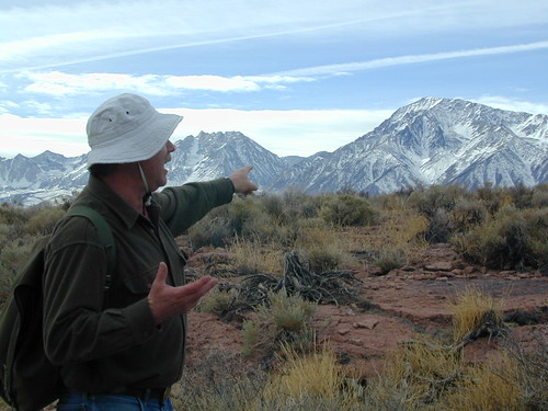
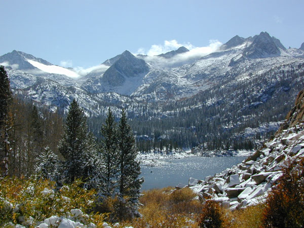
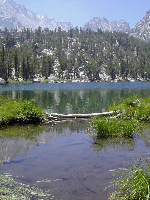
Wilderness seeker John Muir called the Eastern Sierra, the range of light. It’s desery & drastic. Tons of granite & wild-ness. The impressive, tallest peak in the lower 48, Mount Whitney towers at elevation 14888′ over the Owens River Valley. Death Valley meets mountains. Ancient volcanoes & fresh granite. Creeks are alive throughout summer. Alpine lake hikes & their wild flowers are incredible. Horseback trails, rentals, pack trips are very popular. Total Escape even list high country Inyo 4×4 routes, that overlook Bishop.
Eastern Sierra forest & parks –
Inyo National Forest
Toiyabe National Forest – north (Carson)
Toiyabe National Forest – south (Bridgeport)
Ancient Bristlecone Pine Forest
Eastern Sierra maps & trails –
Eastern Sierra towns –
Aspendell, Big Pine, Bishop, Crowley Lake, June Lake, Lee Vining, Lone Pine, Mammoth, Olancha, Toms Place
Quatal Cyn: Forest Road #9N09 – Los Padres National Forest
Toad Spring Campground is located at high elevations (5700′) of Quatal Canyon, on a dirt road, half mile off the pavement of Cerro Noroeste Rd. The Chumash Wilderness, the Cuyama River Valley, Apache Saddle, Mount Abel plus the Bittercreek National Wildlife Refuge all surround this region. Los Padres National Forest meets the vineyards, orchards & farmlands, near Ventucopa. This is the badlands – 18 mile scenic dirt road, well signed at Hwy 33 & mostly graded. Quatal Cyn connects Ojai’s Highway 33 to the pinyon pine forest above near Pine Mountain Club (@ nearly a straight line?) Motorcycle dirt bikes & off-roaders dig this place. Street bikes will prefer paved Cerro Noroeste which runs the rim above to the north.
This major dirt road is not gated at either end, but winter sometimes closes the route due to snow depth. It never stays closed very long, as some beefy 4×4 will break thru the snow berm soon enough. Top elevation @ Cerro Noreste is approximately 5500′.
Quatal Canyon (possible Chumash word for Snake) is a giant high desert wash, ripping down from Cerro Noroeste (aka Mt Abel). Serious erosion w/ San Andreas fault lines – make it a very interesting canyon to explore on foot, horseback, motorbike, or mountain bike. The lupine & wildflowers here are incredible in late Spring in this red dirt canyon. Both nearby mountain peaks of Mount Abel & Mount Pinos are the tallest in Kern County.
This rugged primitive canyon gets torn up during a good storm in late summer or a big winter storm. Red dirt gets very slippery – especially on the edges of a cliff. Boulders in the road, flash floods – or no road, river of mud! 2WD passenger cars can take this route in dry months, but high clearance is usually preferred. 4×4 is needed during heavy rain or snow – which could be half the year (Nov-April). Flash flooding is possible all over Los Padres NF, so know the weather forecast in advance.
Seen small RVs, trucks pulling trailers & even a U-haul moving truck down this way. MapQuest always amazes me where they route you. This is a graded dirt road, some of the time. MapQuest should post a ‘see Total Escape for this route’. Come on folks, if you’re traveling cross-country, while moving your residence, buy a real map to explore the National Forests of California. You may end up sleeping way out here – broken down in the moving van, in the boonies & no cell coverage, cuz you had a one page, wrinkled map in faded ink, wet & smeared. And MapQuest told you it was paved. It’s not paved 90% of the way.
Primitive camping is also allowed in the canyon wash or on the side routes, in certain seasons. Use an existing camp site when possible. Clean out the rock fire ring of litter & bottles, pull back all dry brush at camps & leave these places better than you found ’em. There are hundreds of dispersed campsites out here. The open wash is especially nice on a full moon hike, just bring friends – cuz it is considered “big cat country”. Camp fire restrictions are in tight control on this SoCal region. You will need a camp fire permit, a big shovel & lotsa water. Check with the Los Padres rangers to make sure. Recently Zaca Fire (2007) & the month long Day Fire (2006) both came very close to this precious sanctuary.
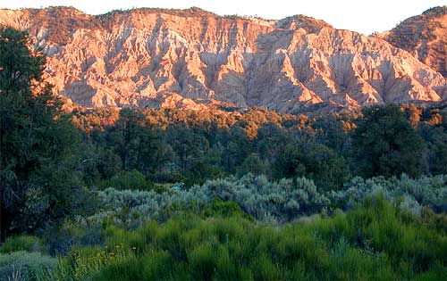
The high desert terrain is pinyon forest, with yucca & manzanita. The eroded cliffs of red rock, white & orange hues, glow best during the clearest sunsets. You will almost think your in Utah, until you get up on a ridge & see the smog in the Central Valley of California.
Mahu Tasen, a Native American camp and sweat lodge, has ceremonial grounds in a canyon off of Quatal. There is also a large rock quarry mining operation, as well as numerous wineries and ranches along this route. Several private residences too.
Ballinger Canyon OHV Park is close by, 5 miles N on Hwy 33
Carrizo Plain National Monument is also pretty close, N off Hwy 166
towns nearby –
helpful maps of the region –


There are so many gorgeous mountains and high deserts in California, that just choosing a perfect horseback ride destination can actually be fun. Browse this extensive list of all local providers. City folks need to consider the colder weather at the higher elevations: bring jackets, hats and warmer clothing.
![]() SoCal areas for horseback are Big Bear, Idyllwild, and San Diego. Horse riding Central Coast regions could consider these places Big Sur, Carmel and Paso Robles. NorCal Coast has the Sea Ranch, Mendocino; but the Sierra Nevada and Gold Country are prime destinations with wildflower creek beds and oak foothills all they way up to the high country alpine granite splendor. Horseback rides in CA
SoCal areas for horseback are Big Bear, Idyllwild, and San Diego. Horse riding Central Coast regions could consider these places Big Sur, Carmel and Paso Robles. NorCal Coast has the Sea Ranch, Mendocino; but the Sierra Nevada and Gold Country are prime destinations with wildflower creek beds and oak foothills all they way up to the high country alpine granite splendor. Horseback rides in CA
Overnight horseback riding
Also called pack trips, or pack trains, these are trained animals (horsea, donkeys, mules, or llamas) that carry your heavy load up the mountain, while you hike solo nearby. Or you can ride the horse, and have another horse carry the gear. Many high elevation back-country can be reached this way – in the warmer months, after the snow has melted. Sierra lake fishing trips by horseback are very popular tours. Find outfitters in Cali for horses, or check out the Llama Trips.
see also – Horse Drawn Carriage Rental
Here is a list of some of California’s most horse friendly towns, some of which have limited winter access:

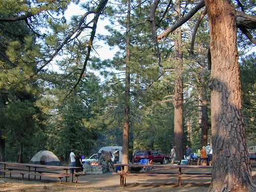
MOUNT ABEL, California
So many misspell Abel like Able, its a wonder anyone can find this place.
But what a nice find it is! Camp O Alto Campground, among the giant trees. RV friendly
Cerro Noroeste / Mt Abel / Noroeste Peak
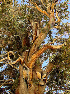
Los Padres mountains, camping on the back roads, mountain biking, hiking, exploring. This gorgeous 8286′ mountain peak sits just to the west of Mount Pinos @ 8831′ (the tallest peak in Kern County). Home of the Jesus Tree, the best sunset spot for miles and the infamous motorcycle road out west, this mountain is one of the lesser known in Southern California. Oddly shaped, Jefferey and Ponderosa pines towering above have their tops stunted and enormous branches hanging down. Maybe from lightning strikes, or maybe from a historic Tejon earthquake that snapped them?
Camp-O-Alto is the official name of this primitive open, FREE campground. First come basis. This place is a perfect option B, instead of the busier Mt Pinos Recreation Area that is located to the east. RV campers love this camp, as there is plenty of room to spread out in between the sites. There is also a large group site at the west end of the campground – available to whomever can grab it first, but you must have a large group to utilize this spot.
Just south of Apache Saddle, there is a faded, large sign that reads Westside Park, but this is the only reference we can find and no one locally calls this mountain by this name. The Cerro Noreste Road gate (near Camp Condor), closes seasonally for winter snow and rock slides.
Once you are past this gate & start climbing from the saddle, there is a great viewpoint a few miles up on the right side, overlooking red dirt beauty of Quatal Canyon. You can see the mountains out near the coast, as well as the high desert, natural wash on the left side and the faint graded dirt road paralleling it to the right side, all mixed up amongst the pinyons & junipers. The Chumash Wilderness is on the left side.
DIRECTIONS TO MOUNT ABEL:
To get here from Interstate 5, exit Frazier & head west, thru Frazier Park, thru Cuddy Valley, turn right on Mil Potrero Hwy (forest road #9N05) & past the golfing community of Pine Mountain Club; continue west to Apache Saddle. At this intersection, turn left on to Cerro Noroeste (#9N25) & drive 10 miles to the top of the mountain.
To get here from Hwy 166, take the Cerro Noroeste Road turn off just east of Hwy 33. Continue 20-something miles up to Apache Saddle ranger station. At this intersection, turn right on to Cerro Noroeste (#9N25) & drive 10 miles to the top of the mountain.
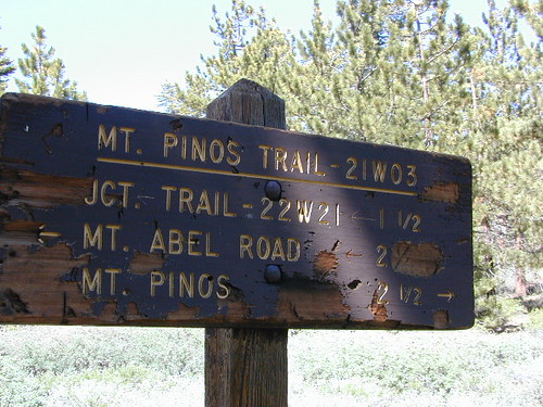
Los Padres Trail # 21W03 / Chumash Wilderness
Hiking Trails / Mountain Bike SoCal
This area is very popular among mountain bikers and sunset seeking couples. The “Peak to Peak” hike is an all day adventure of 6.5 miles, that should be planned well in advance – with another shuttle car at the Pinos parking lot. This is a moderately, strenuous hike that can take up most of the day – with awesome views over the San Joaquin Valley, Lockwood Valley, Pine Mountain Village and San Emigdio range. The area located in between Pinos & Abel is called the Chumash Wilderness.
Total Escape specializes in California locations & the beautiful Sierra Nevada mountains are the backbone to the gorgeous golden state. From the Tehachapi Mountains to the Lassen Volcano, we cover the best back roads for camping, fishing, biking, hiking, kayaking, backpacking, off-roading & hot springing.
Summer is the time to explore the High Sierra. During the fall, winter, and spring, precipitation in the Sierra ranges from 20-80 inches, mostly as snow above 6000′ elevation.
Giant Sequoias are the most massive trees in the world. Sequoia trees can be found in several locations within the Sierras, from the Western Divide Hwy to northern areas of Yosemite Park on Hwy 120. Within Total Escape you can find the hidden groves too.
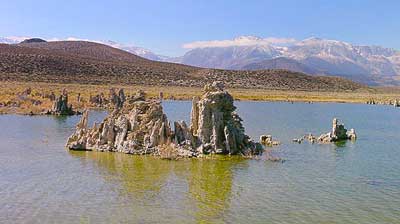
Eastern Sierra along Hwy 395, is all about the drastic elevations & volcano valleys. The Mono Craters are the youngest mountain range in North America. Located near Mono Lake & Lee Vining CA.
National Forests & Wilderness areas within the Sierra Nevada range:

| The most popular Sierra destinations: | Some unheard of spots in the Sierra Nevada: |
County Line trailhead in Stanislaus National Forest, Sonora Pass
Here at Total Escape we known the subtle sensations that come with nature: overlooking a great view of scenic wilderness, or finding that perfect creekside campsite, or crossing that dry lake bed, real fast. Photographs are worth more than 1000 words. This web site is nearing a dozen years online & the founder, DanaMite, has burnt thru only one Nikon digital camera (so far).
If you are searching for a special place to relax, or to explore, you’ve come to the right spot.
Sequoia XC Ski Areas – Park Skiing
Sequoia National Forest & Sequoia National Park do not have any major snow ski resorts. Shirley Meadows Ski Park in Alta Sierra is the closest thing to a facility that exists in the Southern Sierra Nevada.
Cross Country snowy terrain exist in the lower Sierras, you just hafta look to find it. The local rangers in Kernville can tell if there is any good snow on the 7000′ ridges & what places are plowed already & have trail head parking open. It’s quite a seasonal thing you know?
Sequoia National Park is open year round, permitting the snow plows can get thru on Hwy 198. Kings Canyon highway is closed for winter months. Excellent cross-country skiing & snow mobiling trails @ Big Meadows Rd.
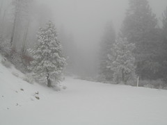
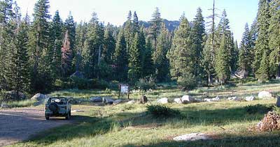
Shermans Pass in April 2007
Originally uploaded by danamight
Camping in the spring on the Kern River can be wonderful, even as it snows nearby. This is the middle of the highway, well after the first snow gate.
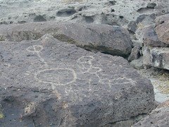
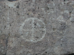
On the north end of Bishop CA, running parallel to & on the west side of Hwy 6, is a long dirt road called Fish Slough Rd. Indian petroglyphs can be found out here & also on the ridges along Chalk Bluff Rd (to the south). The entire region is called a volcanic tableland & hot springs are very common in this region. The Owens River Gorge & Lake Crowley are to the west. High clearance vehicles are recommended for traveling these back roads, but 4×4 is rarely needed.
Read & see more on Fish Slough Petroglyphs