Tag Archives: maps

San Diego Lakes

San Diego county has numerous recreational lakes, but only a few that allow overnight camping. Oak filled valleys and pine forests are nearby, but if you are seeking alpine lakes, surrounded by granite peaks and towering forests – then look to north for the Sierra Nevada mountains. Southern California landscape is nearly a desert terrain, with seasonal creeks and minimal rivers, so you won’t find lush greenery with natural lakes down here.

lakes San Diego

cleveland National Forest map

Angeles Campgrounds

Camping Los Angeles – Angeles Crest Camping

Angeles Crest Hwy CA 2

campground elev spots veg toilet water notes
Appletree Campground 6,200′ 8 pines vault piped Big Pines Hwy
Basin Campground 3,400′ 15 CLOSED
Bear Campground 5,200′ 15 vault no
Big Rock Campground 5,000′ 8 vault crk sm RV, 4WD
Blue Ridge Campground 8,000′ 8 pines vault no May-Nov, sm RV
Buckhorn Campground 6300′ 40 pines vault no May-Nov, sm RV
Cabin Flat Campground 5,300′ 12 vault no CLOSED
Cienaga Campground 2,100′ 12 oaks vault no May-Dec
Coldbrook Campground 3,350′ 22 vault piped sm RV
Cottonwood Campground 2,600′ 22 vault no
Guffy Campground 8,300′ 6 vault no May-Nov, 4WD
Horse Flats Campground 5,700′ 25 pines vault no April-Nov
Jackson Lake Campgr 6,100′ 8 pines vault summer May-Dec
Live Oak Campground 2,000′ 7 oak CLOSED
Manker Flats Campground 6,000′ 21 flush piped sm RV
Messenger Flats Camp 5,500′ 10 pines vault no Corrals, April-Nov
Millard Campground 1,900′ 5 oaks vault no Altadena, Chaney Trail
Monte Cristo Camp 3,600′ 19 oaks vault piped RV, Hwy 2, N3
Mount Pacifico 7,100′ 7 pines vault no May-Nov
Mountain Oak 6,200′ 17 oak flush piped May-Nov
Peavine Campground 6,100′ 4 vault piped Big Pines Hwy
Prospect Campground 2,100′ 22 CLOSED
Rocky Point Camp 3,400′ 3 vault summer
Sage Campground 3,400′ 4 vault no Cheseboro Rd
Sawmill Campground 5,200′ 8 vault no sm RV
Soledad Campground 2,000′ 6 CLOSED
South Fork 4,500′ 21 oaks vault no May-Nov, sm RV
Spring Camp 4,700′ 3 vault no Rincon-Shortcut Route
Spunky Campground 3,300′ 10 vault no
Streamside Campground 2,500′ 9 vault no poison oak
Sycamore Flats 4,200′ 11 vault summer sm RV
Upper Shake 4,400′ 18 vault no May-Dec.
Zuni Campground 1,700′ 10 vault no

Chilao Campground

tunnel angeles crest

nearby towns –

Angeles Maps – hiking, OHV & mountain biking –

4×4 Rock Crawling

poppin

Rock Crawling has gained massive exposure in the two last decade with new suspensions, after market part for nicer rigs & of course, the main stream media. Red Bull, Skyjacker & other corporate sponsors have dug their hands into this new sport & the profits.

Crawlin’ is the off road hobby of wheelin’ well built rigs over the rocky terrain and obstacles, instead of around it. Sandstone walls, granite boulders of the High Sierra, hand made “rock gardens” in the Mojave, practice runs @ the local OHV parks.

Breaking things is the norm in this game. Expect this past time addiction to cost a bundle – on auto parts & on your free time. On the trail repairs are common, so go prepared w/ your tools, overnight gear & your crawling buddies (as back up).

From the adventure lands of Moab, Utah to the Mojave Desert of SoCal, rock crawling is not about speed, but all about the delicately chosen lines & slowness. The technique, the rigs & preferably no body damage. Just get rid of the body!

How slow can you go? How high can you handle?

Popular rock crawling areas around the Southwest U.S. –

California OHV Trail Maps

OHV Routes, Motorcross & ATV Maps

local boys Los Padres

Partington Cove Hike in Big Sur

Big Sur – Partington Cove

DSCN3026
Go west to & visit the oceans edge or head east to explore a deep redwood canyon.big

Approx. 5 miles South of Big Sur State Park and just north of Julia Pfeiffer Burn State Park, this unmarked dirt turnout area on Highway 1 is a rare find. Rocky shorelines at the historic point, plus the scenic tree lined waterfall & cross the highway & head east for a shady Redwood canyon forest with plenty of backpacking options into the Big Sur back country of Los Padres National Forest. From bright sunny ocean view hillsides to dark shady forests.

This portion of the highway cuts into a deep bend along the coast & has no markings to the paradise that lies within. A steep dirt fire road (down to the cove) with metal gate is your only clue. Dirt parking area on both sides of the road indicate that people have parked here before.

This un-signed secluded hide-away has a variety of landscape & sites to see. You could easily kill 6-8 hours just in this canyon alone!! Definitely not a hurry through kind of place. Take your time, enjoy the view, tide pools, bring your swim suits & refresh in the creek. Carry a picnic eastbound into a shady creek-bed canyon & watch the sun dance through the towering pines above.

Driving northbound on Highway 1, look for large hair-pin turn out in canyon area – approx. 3-5 mi. North of Julia Pfeiffer State Park in wide dirt areas along roadside. Located in between Julia State Park & Pfeiffer Big Sur State Park.

Hike down the dusty wide gated fire road in dry brush chaparral. The view of Redwood trees, the royal blue ocean in front of you, the sounds of a water falling creek. The trail forks off in 3 directions:

Right / Rock Beach – this a boulder lined cove where the clear fresh water stream meets the ocean. Small pools & waterfalls can be found just upstream .

Bridge Crossing / Point – through a wooden tunnel to a cliff area with tide pools & wooden structure (an old boat launch?)

Left / Up Stream – a forested canyon w/ a variety of trees; dead ends a few hundred yards up into the canyon

DSCN3021Another option to this canyon is the East side:

Hike up inland (away from ocean) into a densely forested creek area. Redwoods, waterfalls & boulders. Deer sightings are quite common in this area. Shady & dark this trail climbs gradually in elevation. One fork of the trail leads to an old Redwood Grove. A portion of the trail is closed 2.5 mi. up due to a landslide. But overall the is a perfect option for backpackers wanting a short hike.

  • Los Padres Maps (USDA)
  • Big Sur Map (NatGeo)
  • Ventana Wilderness Map w/ Silver Peak
  • Los Padres Camping

    Los Padres Campgrounds
    Big Sur, Mount Pinos, Ojai, Santa Barbara, Santa Lucia

    Forests

    Los Padres National Forest campgrounds span the length of the California Central Coast, from the Monterey Bay to Los Angeles County. Choose a desired area:

    Big Sur Campgrounds

    Frazier Park Camping

    Mount Pinos Campgrounds

    Ojai Camping

    Santa Barbara Camping

    Santa Lucia Camping

    Bottcher Gap Campground
    Lush coastal campground is Bottchers Gap near Big Sur, CA

    Los Padres National Forest

    see also Los Padres Group Campgrounds

    maps of the Los Padres regions –

    Los Padres nearby towns & cities –

    Pine Mountain Club from ridge
    Pine Mountain Club from ridge

    Pine Creek Wilderness

    Pine Creek Wilderness Area
    East of San Diego, California

    • 13,400 acres
    • gently sloping area
    • elevations range – 2,000′ ­ 4,000′
    • vegetation is chaparral & scrub
      oak
    • riparian & woodland vegetation in stream
      bottoms
    • Pine Creek & drain the area north to
      south
    • rainbow trout in Pine Creek
    • streams are dry for parts of the year
    • several trails provide access to area
    • wood fires prohibited
    • portable stoves permitted
    • groups limit – 15 people
    • visitor permit required
    Cleveland National Forest
    Descanso Ranger District
    3348 Alpine Boulevard
    Alpine, CA 91901
    619-445-6235

    Pine Creek Wilderness Map

    San Diego Trails

    San Diego Hiking – San Diego County Trails

    horse hiking

    Cedar Creek Falls
    3 mi RT / moderate; off Hwy 78

    From Santa Ysabel on Hwy. 78, drive E 6 mi, turn right on Pine Hills Rd.
    1.50 mi., bear right on Eagle Peak Rd.
    1.25 bear right again (signs point to Eagle Peak Ranch)
    Drive 8 mi. (dirt & paved) to Saddleback, 4 way junction.
    Park & hike the fire road downhill for 1.25 mi.
    At the fork, bear left & continue into the Cedar Creek bed
    Some rock scrambling down to the swimming hole

    Hot Springs Mountain
    5.5 miles RT/ strenuous (elevation gain/loss =1,250 feet)
    Near Warner Springs, 10 miles northeast of Lake Henshaw; Off Highway 79

    From Temecula Interstate 15, take Highway 79 East to Warner Springs
    Drive up Los Coyotes’ Indian Reservations main road, past the intersection of Middle Fork Borrego Palm Canyon (6.1 miles past the entrance gate )
    Turn left (west) and drive up the valley on a sandy road to reach a saddle above the valley 2.2 mi. farther
    At Nelson’s Camp, on the left side of the road, Park at the camp
    Begin hiking southwest up along a small tributary stream that flows north & west into Agua Caliente Creek.
    Follow an old Jeep trail up, gaining more than 500 feet in just over a mile.
    At the top, you’ll meet a better road that runs up the south slope to Hot Springs Mountain
    Turn left (west) on this road and climb another 1.6 miles along the ridge line to the tower.
    Pass through dense forests of black oak, Coulter pine and white fir, and across meadows dotted in late spring with wildflowers.
    Lookout tower, dilapidated and seemingly on its last leg, sits on the west shoulder of the mountain.
    Go a bit higher on the ridge by following a faint trail through thick brush and around boulders to the true summit. A flat concrete platform caps the summit block.
    option – Seven-mile dirt road going up the mountain’s southern slope (drive, hike or mountain bike)

    Maps Mountains / San Diego Maps

    see also – San Diego Anza Borrego 4×4

    Hauser Wilderness

    Hauser Wilderness Area

    • 8,000 acres, south of Interstate 8
    • steep slopes & granite boulders
    • vegetation is chaparral & coastal sage
    • elevations range – 1,600′ ­ 3,681′
    • Pacific Crest Trail passes to the east
    • Barrett Reservoir
    • wood fires prohibited
    • portable stoves permitted
    • groups limit – 15 people
    • visitor permit required
    Cleveland National Forest
    Descanso Ranger District
    3348 Alpine Blvd.
    Alpine, CA 91901
    619-445-6235

    Hauser Pine Creek Wilderness map

    PCT Maps

    Hiking Trails San Diego

    San Diego Mountains

    San Diego Mountain / Hiking San Diego / SoCal Camping

    hiking San Diego

    San Diego forests & parks – 

    Cleveland National Forest

    Palomar Mountain State Park

    Anza Borrego Desert State Park

    San Diego maps & trails –

    San Diego mountain towns nearby Alpine, Descanso, Julian, Mount Laguna, Palomar, Ramona

    mt laguna lodge

    Split Mountain Anza Borrego

    Anza Borrego Desert State Park

    Fish Creek Campground

    E of Borrego Springs CA.

    Well off Highway 78, past the busy OHV area, quads at Ocotillo Wells, past all the rural homes & the redneck bar, past the Elephant Trees hike – where the road goes from pavement to graded dirt to a wild desert wash, in a few short miles. If you don’t know where you are, then you’re almost there.

    This is a large wild desert wash with huge unstable walls, several areas for wind caves and a few historic markers. Lots of 4×4 trails beyonf Split Mountain, to the south. No real water in sight, except maybe the puddle you are standing in as it starts to poor. The soft sand can give way to a few heavy rain drops. May not be a great area to be during a serious storm or flash flood possibility, unless you want to get buried alive. Check the weather forecast in advance.

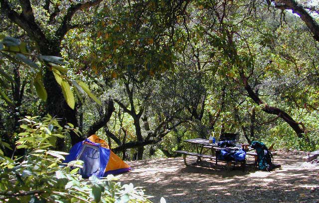
    A ratty, small developed campground of Fish Creek is on the left side, upon the ledge. Fish Creek Campground is picnic tables & a pit toilet – at most. Ya may as well camp out in the open, off road, like the pioneers did. You can do that out here in Anza Borrego. (Just keep it clean & carry a metal fire container.)

    split mountain

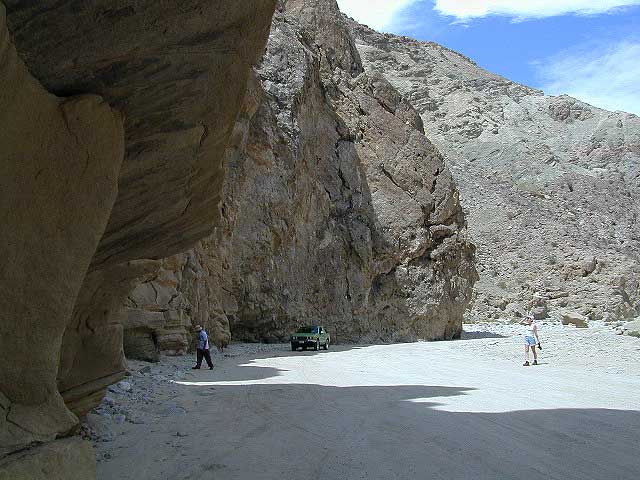
    Split Mountain, Anza Borrego Desert State Park

    This portion of the “mountain” is less than a mile from Fish Creek Campground. Fossils can be found in these walls. Shade is good in summer months, when day temps reach 100+. The rest of the year is ideal weather. This mountain split from water, erosion, mega force. High walls, wind caves, desert washes, great primitive camping & 4×4 routes.

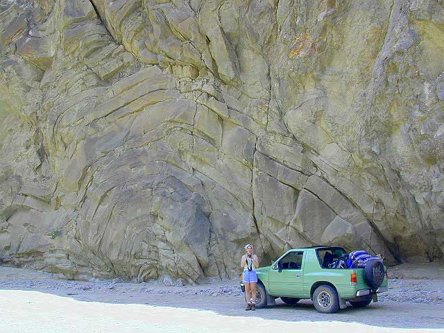
    This desert scenic drive will require you to get that SUV dusty. 4 wheel drive not required. No RVs past the campground. All low lying passenger cars are warned, there are uneven areas, soft sand & boulders.

    Duh, do not attempt this one when desert flash floods are possible.

    ANZA BORREGO STATE PARK

    ANZA BORREGO MAP

    SAN DIEGO BACKCOUNTRY MAP

    nearby towns –

  • BORREGO SPRINGS CA
  • OCOTILLO WELLS CA
  • SALTON SEA CA

    splitmountain

    Great desert back road exploring out here. A zillions washes & canyons.

  • Eastern Sierra Mountains

    Eastern Sierra Mountains / Eastern Sierras California

    mount tom

    Wilderness seeker John Muir called the Eastern Sierra, the range of light. It’s desery & drastic. Tons of granite & wild-ness. The impressive, tallest peak in the lower 48, Mount Whitney towers at elevation 14888′ over the Owens River Valley. Death Valley meets mountains. Ancient volcanoes & fresh granite. Creeks are alive throughout summer. Alpine lake hikes & their wild flowers are incredible. Horseback trails, rentals, pack trips are very popular. Total Escape even list high country Inyo 4×4 routes, that overlook Bishop.

    Eastern Sierra forest & parks –
    Inyo National Forest
    Toiyabe National Forest – north (Carson)
    Toiyabe National Forest – south (Bridgeport)

    Ancient Bristlecone Pine Forest

    Ancient Bristlecones

    inyo maps

    Eastern Sierra maps & trails –

    Eastern Sierra towns –
    Aspendell, Big Pine, Bishop, Crowley Lake, June Lake, Lee Vining, Lone Pine, Mammoth, Olancha, Toms Place

    south lake bishop

    cottonwood lakes