|
Mt.Gleason Angeles NF
1-2 days [ Los Angeles
Co.]
From Los Angeles, take Hwy.2 East, follow 210 jct to Angeles
Crest Hwy.2. Up the mountain, left at N-3/Angeles Forest Hwy.,
pass Monte Cristo campground. Look for wide intersection with
dirt road crossing. Left on Mt. Gleason Rd. (one lane paved) Forest
Service Rd.# . Take the left fork (toward CLOSED: Messenger Flats campground, a dirt road). This high elevation area means
the vegetation changes from yuccas & manzanita to cedar &
jeffery pines. Take the right fork toward Messenger, continue on to Forest Service
Rd.#4N33 & turn right into Moody Canyon. Follow the road to the bottom of the mountain. Hwy 14 is located down in the main
valley.
Contact Ranger District: Tujunga to make sure all roads
are passable & no gates are locked.

Pacifico Mountain Angeles NF
1-2 days [ Los Angeles
Co.]
From Los Angeles, take Hwy.2 East, follow 210 jct to Angeles
Crest Hwy.2. Up the mountain, left at N-3/Angeles Forest Hwy.,
pass Monte Cristo campground. Look for wide intersection with
dirt road crossing. Right on Mt. Gleason Rd. (dirt road) CLOSED: Mount Pacifico Campground; check out some great view
over the Antelope Valley desert. Continue on main road & at intersection, make a right toward Horse
Flats & Bandido camps, where Angeles Crest Hwy.2 can be
accessed. Go right & head back down mountain or turn left
& head over to Wrightwood,
taking I-15 home.
Contact Ranger District: Arroyo Seco to make sure all roads
are passable & no gates are locked.
Upper Lytle Creek Angeles NF
1-2 days [ Los Angeles
Co.]
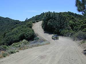
Not for the faint at heart! High clearance vehicle & real
nerves is a must for this one.
From Los Angeles, take I-10 East to 15 North, exit Hwy.138 &
left on Hwy.2 to Wrightwood.
Upon return trip, go the back way through the neighborhood &
Continue down through the Lone Pine Canyon. Right before Clyde
Ranch on right side, turn right on Forest
Service Rd.# 3N31 (dirt & rocky road) & head up hill
over first ridge. For a real rocky bumpy experience, drop down
on right Forest Service Rd.#3N33 & decend into the Lytle Creek
area. A river crossing or two may be at hand depending on the
season. This is an extremely deep remote canyon with tons of hazards
to be cautious of. Rock slides are common, so be aware. Large
old pines trees are lining the river along with a ton of jagged,
sharp rocks. Explore this very secluded area carefully. A few
primitive camp spots are dotted throughout the area. The bottom entrance located to the
left, Stockton Flat Rd./ Forest Service Rd.#3N06, may be still
closed . In June 1997 - Signs reads "road closed
5 miles ahead". If so, head back up Forest Service
Rd.#3N33 & turn right back on to Forest Service Rd.# 3N31
which is a ridge road, with nice views. Turn left on Forest Service
Rd.#3N29 (very narrow) headed downhill towards Sharpless Ranch
& Lone Pine Canyon Rd. At the bottom, turn right & head
back over to I-15.
Contact Angeles Ranger District: Mount Baldy to make sure all roads are passable & no gates are locked.

Rand Mining District
2-3 days [
Mojave Co.]
Take 5N, 14NE, pass town of Mojave & approx.20 mi. Turn
right on Redrock Randsburg Rd., veer left at Y to visit Garlock
Ghostown or right at Y & continue up over the hills to the
old rustic mining town of Randburg.
Great spot to stop & look & take it all in. The real saloon
may be open, (mid-days) if you are lucky. The joint is usually open daily. A small lodge, but food or no gasoline available in this town. Cafe or restaurant? Nada! Both bars have very limited hours on weekend & even less on weekdays. Tons of dirt roads to explore, but be careful of open mine shafts & private property signs.
Side / Add-On Trips:
If you've got the time, head out toward Trona Hwy. & visit
the Trona Pennicles. A lunar looking landscape area that is well
worth exploring. The town of Trona has a gas station.
Continue on into Panamint Valley area & visit Balarat
Ghost town on the right side. If you are headed to Death
Valley National Park, you may want to venture through the
Wild Rose Canyon. Veer
right at Y intersection. This area has tight canyons & cool
rock formations. Left on Emigrant Canyon - WildRose Rd. dropping
down to Stovepipe Wells Ranch.
Sugarloaf Sequoia NF
2-3 days [ Kern
Co.]
Take 5N, 99N to Bakersfield & exit Hwy.178 headed towards
Lake Isabella. Follow
it up mountain & exit Hwy.155 to Wofford Heights & quaint river town of Kernville.
Left at stop sign SM99 & head up the Kern River 30 mi. to
Johnsondale (R Ranch), veer left at big curve, stay on SM-50 &
within 5 mi., Turn left on Forest Service Rd.#23S16 to Thompson Camp Springs. Very popular area with beautiful primitive creekside camping in this area. Turn left on Sugarloaf Rd.
Forest Service Rd. #23S16 (paved). This 18 mi. long ridge road runs through some beautiful Southern Sierra secluded forest.
Great views overlooking the Kern River Valley. Pass Speas Camp.
[Side trip option is over to Baker Point: Left on Forest Service
Rd.#23S02 up to point & back track on #23S80 which leads back
to #23S16] At Portuguese Pass, turn left on Forest Service Rd.#24S15,
then left on #25S16 down to small community of Alta Sierra. At
intersection Hwy.155: turn left back down to Lake Isabella or turn right & go down to the San Joaquin Valley.
Contact Sequoia Ranger District: Greenhorn To make sure all roads
are passable & no gates are locked.
Kennedy MeadowsSequoia NF
[ Kern Co.] 2-3 days
Take 5N, 14NE, pass town of Mojave & continue on to US
Hwy.395 for a few miles. Turn left on Nine Mile Canyon Rd. - Co.Rd.
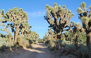
#J41 & climb mountain, passing Joshua trees & Pinyon pines.
This area maybe has one  small lodge & restaurant.
Plenty of horses up here too. Kennedy Meadows has a large campground.
Take Forest Service Rd.#22S05, Just past Troy Meadows at intersection,
turn right on to #21S03. There are tons dirt roads that lead to
nice primitive camping
areas. It is a big equestrian / horse area also.This road ventually
dead ends into Trout Wilderness backpacking parking area. Continue
back on Forest Service Rd.#22S05 / Sherman Pass Rd. which leads
to Kern River Valley. [The mileage is approx. 60 mi. from Hwy.
395 to Kern River] Turn left on SM99 & head to Kernville
& Lake Isabella. small lodge & restaurant.
Plenty of horses up here too. Kennedy Meadows has a large campground.
Take Forest Service Rd.#22S05, Just past Troy Meadows at intersection,
turn right on to #21S03. There are tons dirt roads that lead to
nice primitive camping
areas. It is a big equestrian / horse area also.This road ventually
dead ends into Trout Wilderness backpacking parking area. Continue
back on Forest Service Rd.#22S05 / Sherman Pass Rd. which leads
to Kern River Valley. [The mileage is approx. 60 mi. from Hwy.
395 to Kern River] Turn left on SM99 & head to Kernville
& Lake Isabella.
Contact Sequoia Ranger District: Cannell Meadows To make sure all roads
are passable & no gates are locked.
Stagecoach Route Anza Borrego
SP
1-2 days [ San Diego
Co.]
From Julian on Hwy.78, go east down Banning grade. When you
get to the high desert, take a right on S2 - Great Overland Stage
Route of 1849. Aprox. 5 mi. after Anza
Borrego State Park sign, look for small dirt road on left.
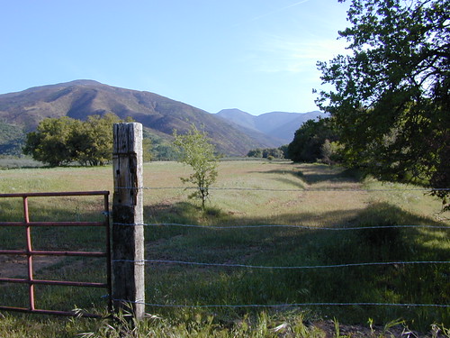
Turn left into Little Blair Valley. At crossroads veer right up
over small pass & continue down into valley. Good primitive
camping & wildflowers
in this area. At T intersection, turn left for the Pictographs
hiking trail or right into Blair
Valley. Anza Borrego State Park is now charging for day use
of this area $5. Collection boxes are set up at both entrances.
Continue staright on back to paved road S2. Turn left & head
southeast to Bow Willow Campground. Across from campground, on
left side is a dirt road - these leads over to Carrizo Stage Station
Site. Backtrack a bit & turn left @ first road, Canyon sin
Nombre, continue back towards highway S2. Follow it until you
hit I-8 & head west to San
Diego.
Big Sur Secret Los Padres
NF
2-3 days [ Monterey
Co.]
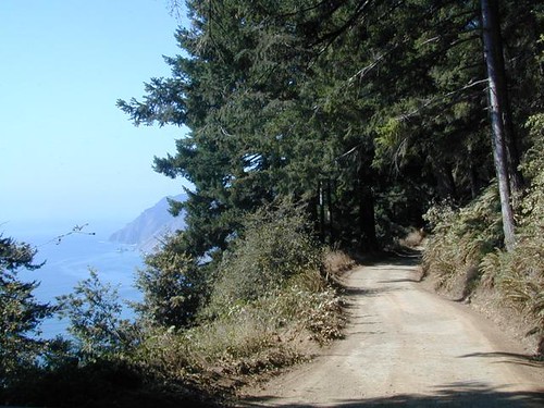
Take the back way into the Big Sur Coast, see some wooded canyons
& above average views of the Pacific Ocean.
Take 101N, pass San
Luis Obispo & Paso Robles. Exit G18 & go left on Jolon
Rd. Take left onto Mission Rd. & visit the old Mission San
Antonio de Padua. Backtrack a mile & head west on Nacimiento-Fergusson
Rd. Two very nice campgrounds are in this canyon along the Nacimiento
River - Ponderosa
& Nacimiento. Right past camp Nacimiento Ranger Station,
you will see a dirt road crossing. Take a left on to Coast Ridge
Trail, Forest Service Rd.#20S05 & continue 5 mi. to right
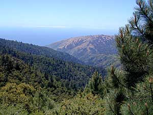
turn up hill #22S04 & onto Prewitt ridge area. Spectacular
Views! Primitive
campspots are dirt road dead ends with small clearings. Continue
back on main road along ridge. Plaskett Ridge Rd.#23S02 (signage is wrong) is closed, but you can find
access to the coast by continuing on the more primitive South
Coast Ridge Rd. #20S05 towards Lion Camp. Drive approx.6-8 mi.
& turn right #23S01 down Willow Creek area. This road will
hit Coast Hwy.1 & you can take your pick to head north to
Big Sur or South to Hearst Castle.
Contact Los Padres Ranger District: Kings to make sure all roads
are passable & no gates are locked.
|