Tag Archives: basin

Gold Lake California

lilgoldlake
Hike-in only Gold Lake, Bucks Lake Wilderness.

California has more than one Gold Lake!

goldsign

Gold Lake, CA

(Sierra Co)
6409′ elev.

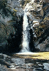
The biggest Gold Lake, California is the well-known one, along the Gold Lake Highway in the Lakes Basin Recreation Area. Plumas meets Tahoe National Forest. North of Gold Country Hwy 49, Downieville & the Yuba River. Right where the Sierra Nevada granite meets the volcanic lava rock of NorCal.

Packer Lake

Lakes Wilderness Map

Impressive jagged spires known as The Sierra Buttes (8591′) tower above the stunning lake scenery. This big Gold Lake is surrounded by a dozen smaller alpine lakes which make up the popular region called Lakes Basin. Easy access paved highway, which closes in winter for deep snow and winter recreation. The Gold Lake Highway is also referred to as Plumas County Road #S620

sierra buttes
the sierra buttes

Sardine Peak Fire Lookout lodgeranger rentals
NFS fire tower – no more overnight rentals!
overlooking the Sierra Buttes and the serene Lakes Basin, Yuba River, Northern Gold Country California

see CalPine Lookout near Sierraville, CA

driftwood

USFS

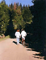
LAKES BASIN RECREATION AREA
Cabins, camping, lake fishing, backpacking, hiking, horseback riding, mountain biking, off-roading, snow-mobiling.

lakesbasinhikers

snowmo

California Lakes

mini gold lake

Mini Gold Lake

(Plumas Co)
6000′ elev.

Another smaller Gold Lake exist on the granite slopes in Bucks Lake Wilderness – E of Oroville & W of Quincy, CA.

gold lake trailheadThis hidden gem is a hike-in only lake – and well worth the effort. A somewhat short hike, great ridge line views to the east, although the last half mile of this route is a doozie (moderately strenuous).

The main trailhead departs from Silver Lake and climbs a ridge line that heads over to the PCT (Pacific Crest Trail). An off-shoot trail goes another mile to the miniature Gold Lake, a granite bowl of sheer beauty. A great day hike for those wishing to see the backcountry. Pack your picnic lunch, camera, and make a whole darn day of it!

Swimming & skinning dipping seem quite natural at this alpine lake, since it is a pretty remote location (without a lot of visitors) and there is absolutely no swimming allowed at neighboring Silver Lake.

bucks trailhead

The steep, overgrown, rocky shoreline leads one to bush whack through old trails, only to be met by a rock slide. Many dead ends and obstacles to climb around, or over. Some way… maybe, or maybe not!

Boulder and rock scrambling is the key phrase to remember, once you reach this lake. Knees may be sore from climbing, up and over the boulder ledge surrounding the lake bowl.

goldshore

Bucks Lake Wilderness Map

A few primitive camp sites are scattered about on the edge of the lake for those backpacking in, but be warned – they can be very difficult to reach. Much more suitable campsites can be found scattered throughout the area.

Warning: there are no flat, lush meadows to lounge in up at the lake, so pick yourself a side route (on the walk in) to find real seclusion and privacy.

view to Quincy

This mile-long-ridge hiking trail to mini Gold Lake has some amazing views down to the east side – Jacks Meadow right below; then Meadow Valley & Quincy off in the distant hills. RURAL CALIFORNIA – Plumas County from above.

jacks meadow
jacks meadow, way below

Sierra Nevada Lakes

High Sierra Gold Lakes in California

hike-in only lakes

hike

Golden Bear Lake
(Tulare Co)
12,000′ elev

High Sierra – Kings Canyon National Park
Center Basin / Center Peak 12,760′
PCT – Pacific Crest Trail
North of Mount Whitney
Eastern Sierra, Independence, CA

hike

Golden Trout Lake
(Inyo Co)
11,500′ elev

Trail #3306 from Onion Valley Campground
North of Mount Whitney
Eastern Sierra, Independence, CA

goldentroutlakecanyon
onion valley trail views
Eastern Sierra Lakes
Alpine Lake above Onion Valley, Eastern Sierra

Mono Lake California

The Great Basin meets California, at the Eastern Sierra Nevada Mountains

Navy Beach, Mono Lake

Mono Lake


elevation: 6383′
Eastern California
US Hwy 395 @ CA SR 120

East of Yosemite NP
Lee Vining, CA

Mono Lake

Rumor has it this lake basin could be the ancient super volcano of the region. MonoLake is located on the north end of the Long Valley Caldera, a volcanic ridge which stretches down to Bishop and parallels Mammoth Mountain & US 395.

Huge shallow lake with a very turbulent history. Signs and plaques throughout the lake shore give info on ancient history of the lake, the wildlife, and regional detail. Majestic views of the Sierra Mountains, with sparse vegetation, lunar type landscape. Eerie with storm clouds; Beware of bad weather. Kayakers love this lake too!

Sierra Nevada backdrop

Canoeing
Hiking
Hot Springs
Kayaking
Picnic
Primitive Hot Springs
Stargazing
Volcanic Landscape

Mono Lake Camping

Camping is closeby, but not located on the fragile lakeshore.
open camping
Dispersed camping (FREE) is allowed in Mono Basin National Forest Scenic Area, the region that surrounds the Tufa State Natural Reserve. Campfire permits are required. Contact the park listed below for all the details on the camping policy.

campgrounds
Camps include National Forest Campgrounds in Lee Vining Canyon (8 miles), June Lake Loop (15 mi), Lundy Lake (12 mi). Private RV parks can be found in nearby Lee Vining and further south, at Lake Crowley.

[PDF download]
Camping In The Mono Basin
by LeeVining.com

Inyo National Forest USDA
Camping Mono Lake Ranger District

local links:

Mono Lake Tufa State Natural Reserve
California State Park
760-647-6331

Mono County Tourism
MonoCounty.org

760-924-3699

Mono Lake Committee
MonoLake.org

Bookstore @ 3rd, Lee Vining
760-647-6595

Tufa Towers

nearby interests:

Yosemite National Park
Inyo National Forest
Toiyabe National Forest
Benton Hot Springs
Bodie Ghost Town
Convict Lake
Mono Craters – Panum Crater & Crater Mountain
Long Valley Caldera
Lundy Lake
California Aspen Groves
Autumn Colors Camping

Long Valley Craters Mono Lake
Long Valley Caldera Craters near Mono Lake

regional maps:

Tom Harrison Mono Lake Map

NatGeo Mammoth Lakes & Mono Map

Inyo National Forest USDA Map

Ansel Adams Wilderness Maps

nearby towns w/ lodging:

Benton Hot Springs
Bridgeport, CA
Lee Vining, CA
June Lake, CA
Mammoth Lakes, CA


View Larger Map

Angeles Crest Hiking

Hiking Trails Los Angeles

another two bite the dust

localhikes.com – GONE
latrails.com – GONE

Millard Falls
2 mi RT; 1200′ elevation; oaks.
Arroyo Seco District –
of Angeles National Forest
818-790-1151
Altadena CA
From Interstate 210 in San Gabriel Valley, exit Lake Ave., go N & turn left/west onto Loma Alta Dr. & to Chaney Trail & follow signed dirt road

LA waterfalls

Sturtevant Falls
5 mi RT; 4600′ elevation; oaks, creek-crossings.
Santa Anita District –
of Angeles National Forest
818-899-1900
inside Big Santa Anita Canyon
From Interstate 210 in San Gabriel Valley, exit Santa Anita Ave.Go North/East, through neighborhood & up mountain to paved parking lot.

More hikes on Angeles Forest

  • Big Tujunga Wash
  • Circle X Ranch
  • Mendenhall Ridge
  • Mount Lukens
  • Newhall Pass
  • Strawberry Peak
  • Towsley Canyon
  • Verdugo Mountains

Hiking Los Angeles Area

Angeles Forest – Los Angeles California

nearby towns –

Angeles Maps – hiking, OHV & mountain biking –