Tag Archives: open all year

Hill Top Hot Springs

Hilltop Hot Springs

hill top hot springs

High Desert: Hill Top
primitive hot springs

May also be known as Pulky’s Pool in hot springs books.

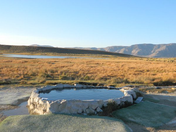
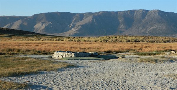
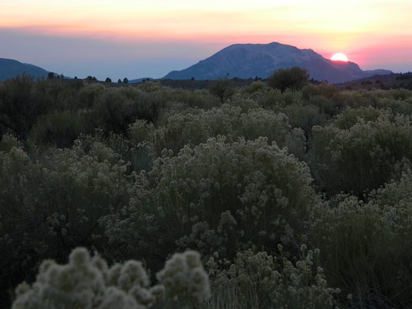
Hilltop is a new found favorite and one of the more scenic spots for a soaking tub in this region. Sitting out in the middle of a clearing, surrounded by marsh lands, this remote hot springs is a hike-in destination. No paved road, nor paved trail. The mountain and sky views from this tub are splendid, and if you time it perfect, you may have the place to yourself.

open all year
elevation:
6,900′

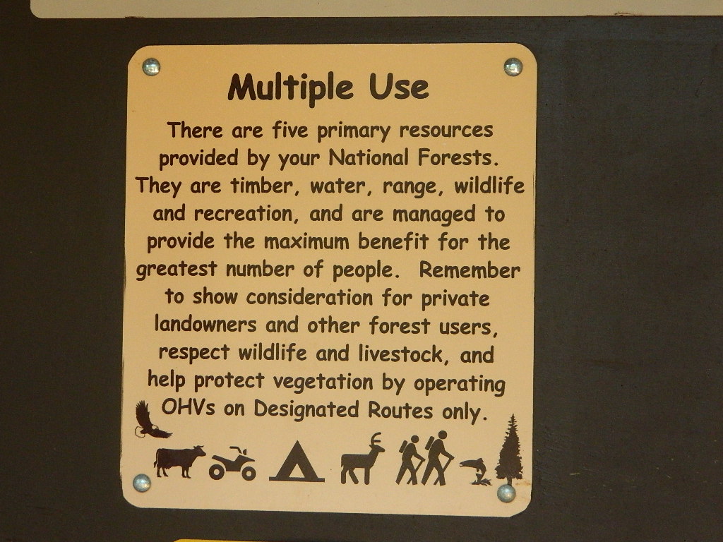
Located in the Long Valley Caldera, this area is managed by Bureau of Land Management

North of Bishop, CA
South of Mammoth Lakes, CA

marsh walk

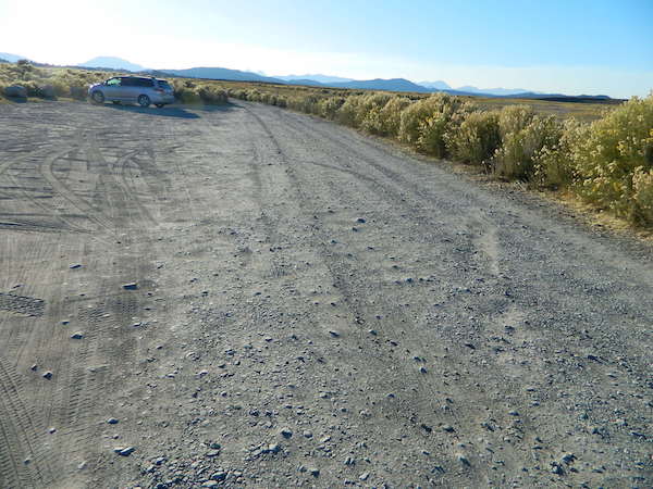
From US Highway 395 @  Benton Crossing Road – drive approximately 3 miles (passing dirt road Whitmore Tubs). Once you’ve crested a small hill, look for a gated dirt road on left, which leads a short ways, back through the sagebrush, to the parking area.

GPS coordinates: 37.6455, -118.8001 

The dirt parking lot is adequate enough to handle a dozen vehicles, and this place is so well known, that it gets a fair amount of traffic at any time of year.

Rumor has it that Hilltop is one of the most visited hot springs near Mammoth Mountain; probably due to the proximity to the paved road. Cars and trucks, camper vans and RVs will be coming and going at all hours of the day and night. So consider yourself warned!

high desert lot

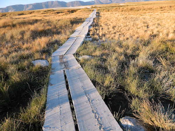
Gate and fence separate the parking from the trail, which leads a quarter mile (often over wooden plank boards) through alkali fields – out to the cement tub.

Only one, small makeshift bench next to the pool – and no tables, no seating, no facilities; Bring tarps, towels, ice chest and camp chairs (if you plan to stay a while).

empty hot pool

Plastic PVC pipes and control valve adjust water flow and temperature. If the valve is left ON (wide open) overnight, the small tub will be too hot to soak in the following morning.

camp

Camping options are pretty limited here. A small clearing for a tent, next to the parking lot; and one decent parking spot, large and private enough to call a camp site (at the dead end, past the parking).

The Eastern Sierra corridor of US Hwy 395 is far enough away that it cannot be heard from this spot.

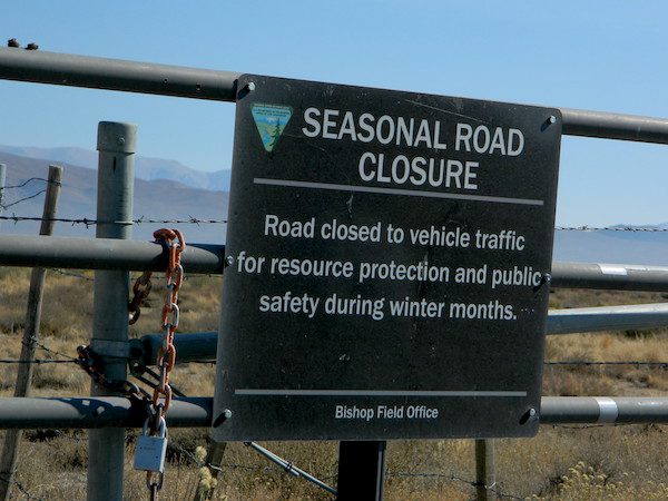
BLM gate at the paved road entrance reads: road is closed seasonally – assuming you can walk in during snowy winter months.

seasonal gate

Hilltop is one of several primitive hot springs in this immediate region. See Mammoth Hot Springs for more choices.

wildfire smoke 2020
Wildfire smoke in 2020 Creek Fire


Fouts Springs

fout springsFouts Springs California

dirtbikes

2018 Mendo Complex Wildfire has affected this area. Expect some closures on trails and roads.

Stonyford Recreation Area
USFS Grindstone Ranger District
Mendocino National Forest

roadtofouts
Paved Road M10, Mendo National Forest

Fouts Campground NFS

Lat – 39° 21′ 35.05307″
Long – 122° 39′ 07.87442″

4x4

OHV

off highway vehicle use is abundant

Fouts Springs is multi-use recreation area on the east side of Mendocino National Forest. Located near the Snow Mountain Wilderness trailhead, this region is popular with the off-roaders and dirt bikers. Expect some noise if camping overnight on a weekend.

Excellent picnic spots along creek in springtime. Wildflowers bloom March-May. Campfire restrictions may begin as early as July, so know current fire conditions.

fouts water

fouts camp

camp

campground elev spots veg toilet water notes
Davis Flat Campground 1700′ 20 mixed vault no OHV + RV trailers
Fouts Campground 1700′ 11 mixed vault piped OHV trails
Little Stony Campground 1500′ 8 pines vault no OHV trails
Mill Creek Campground 1700′ 5 mixed yes no OHV trails
South Fork Campground 1700′ 4 mixed vault creek Stony Creek

Spring Fouts MendoFouts campgrounds are located on the EAST SIDE of Mendo NF on paved road M10. Situated below 2000′ elevation and open year round.

Road M10 Mendo
Road M10 Mendocino

TRAVELERS NOTE: Tent campers, RV and truck campers can easily access this area, all paved roads. Exit Williams or Willows on I-5 and head west. A decent back country map or Mendocino National Forest Map is advised; Numerous canyons, forested creeks and campgrounds. Always check with Mendocino National Forest for road closures and conditions.

dirt bike crossing

OFF-ROADERS NOTE: Use caution on paved access road M10, especially when driving with trailers or large RVs. Narrow road, long and winding with blind curves and no guard rails. Always check with Mendocino National Forest for road closures and trail conditions.

4x4

Mendocino Ranger Stations can be found on link below

NFSMendocino National Forest

foutspicnic

picnic

wildflower

Roxie Peconom Campground

Lassen Forest Road #29N03
Roxie Peconom Camp

Roxie Peconom

MAIDU INDIANS: Roxie was a native medicine woman and lived over 100 years in these parts. Read more here

AUG 2021: Closed due to the Dixie Fire

Wild onions were found along the top of Thompson, Diamond, Eagle Lake, Willard, and Mountain Meadows.

Lassen National Forest – W of Susanville, CA

This pine forest is home to the developed NFS campground – which has been named after the tribal elder. The camp location is a sacred spot to the local native tribes. Just above Susanville, CA on the west side, south of the highway; forested w/ creeks and aspen groves. Autumn colors can be found in the creek beds.

Dirt roads all over the place, leading to far away destinations like Diamond Mountain, Antelope Lake and Taylorsville. The backcountry region was recently damaged by wildfires: 2020 Sheep Fire and now the Dixie Fire 

pinetree

FREE CAMPING – W Susanville, CA
en route camp

Less than 3 miles of dirt road #29N03 driving will get you back off the highway and into this forest, Hwy 36 W of Susanville. Bring the mountain bike for abundant usage and a week of exploring.

Only 13 miles to downtown Susanville, via the back road. Chaney Creek Road is a main dirt road near Highway 36, which parallels the river, the red rock bluff and the road, downhill into town.

This FREE campground is popular with the hipcampers and pediums – and gets rave reviews; small RV campers do like to use this camp spot, if they don’t mind a little dirt road driving; they’ll need to park in the dirt parking lot, 40+ feet away (not adjacent to the picnic tables or fire rings).

  • camping

  • ceremony

  • drum circle

  • fishing

  • hiking

  • horseback trails

  • hunting

  • mountain bike

  • off road trails

Roxie Circle
Bear Dance Circle @ Roxie

roxie seating

walk in campground, and close to town

hiker

Shady Campground

Walk-In Campsites @ Roxie

AUG 2021 – CLOSED due to the Dixie Fire

Roxie P Campground
Susanville, CA – Lassen NFNFSlogo

• Elevation: 4,800′
• Number of Sites: 10 (walk-in only)
• Vehicle Accessibility: any
• Campsites Reservation: No
• Campsite Fee: No
• Length of Stay: 14 Days
• Season: open all year
• Trailheads: Diamond Peak


shadycamp

Flat forest and easy to walk. Shade and pine needles, picnic tables and group fire pits. All facilities are encompassed with a  sturdy wooden, fence line. No RV or trailer access to camp sites. Mountain bikers like this spot and so do horseback riders. Travelers passing through eastern California will welcome the convenient location, plus the ease of dirt road.

The Roxie Camp is situated near Willard Creek on the south side of the Highway 36, close to Susanville. Willard is a feeder stream into the Susan River, which flows into town.  Quiet camp, most of the time. If a big family is camping here w/ children, or there is a tribal gathering, it could get loud.

PLAN B –  head over to Goumaz Campground NFS, due north. Located in between, near the junction of Hwy 38 & 44. Near the railroad tracks and the Susan River. Smaller camp near the NRT (National Recreation Trail), the  Biz Johnson Trail (BLM).
2021, this camp is CLOSED!

so find someplace else: PLAN C
(make sure any camp is open by calling rangers before traveling).

Fire Lookout hike near Milford Grade

Susanville Hiking Trails PDF
BLM Southside Trails
mountain bike, hike, horseback

aspenroxie
Aspen trees at Roxie in Autumn

dirtbikes

off road Susanville

OHV activity may be passing the developed campground, but are discouraged – due to the layout of camp. Plenty spots for ‘froaders further out – at the end of the road. Way back there!

Jeeps, 4×4 trucks, quads, dirt bikes, anglers and hunters travel these dirt back roads, as well as rangers, campers, horses, mountain bikes, and big logging trucks. 25 mph slow is always best. Daytime headlights help you get seen in the shadows. Forest is dense and road conditions are ever changing.

Forest Road #29N03 is Gold Run Road, the bumpy dirt road – that skirts around Diamond Mountain on the south side. Lots of one single track or one-lane dirt roads, which will require a National Forest map or a decent topo map to navigate properly.

OHV is common in these areas, but not so busy at this camp. If you seek peace and quiet and solitude, know how to read a map and where the noise is expected to be. Avoid the OHV areas, if you want to nap in the hammock and read a book.

Wild red necks with guns live in NorCal, so pay close attention to property lines and trespassing signs.

ranger

USFS Ranger Station is located on the west side, just outside of town, on the wide downhill grade on the highway @ the Eagle Lake turnoff. Cal Fire station is also located along this stretch of road.

Lassen National Forest
Ranger Station USFS

CA-36 @ Eagle Lake Rd
Susanville, CA 96130
530-257-4188

Cal Fire Station
697 CA-36, Susanville, CA 96130
530-257-4171

fish

NEARBY TOWNS:

Chester, CA
Lake Almanor, CA
Susanville, CA
Westwood, CA

Susan River is nearby, but not really walking distance from Roxie Camp

eagleclouds
Large Eagle Lake, N of Susanville, CA

Year Round Camping

Year Round Adventures

CampingCalifornia is an outdoor recreation paradise, with near perfect weather, diverse terrain and breathtaking scenery around every corner. Many folks gravitate to the west coast specifically to be outdoors more.

Soaking in the sunshine, every day, every week. Reconnecting with nature and choosing to live a more healthy lifestyle, eat well and learning to relax often. Camping can be a real vacation – without the high cost of travel.

Summer isn’t the only time to go camping in California

Avoid crowds
Try getting out there before Memorial Day or after Labor Day!

Desert camping is popular during winter months, while mountain destinations are preferred in summer. Find a secluded small campground or even try roughing it w/ primitive car camping. Motorhome campers who like to boondock, will enjoy the extensive back roads section of Total Escape. If you own a 4WD vehicle, you can reach the most secluded 4×4 camps, lookout towers and some historic cabins.

season description recommended
Summer hot in deserts & country foothills,
smoggy in cities; coastlines can be foggy
mountains & coast
Autumn great camping all around,
early winter storms in mountains
coast, deserts, country
Winter snow in mountains & very cold,
windy on coast as seasonal storms move in
deserts (possibly)
Spring snow melt in mountains may be late,
storms can last into late springtime
deserts & country

Picnic Tables

annual timelines to consider

  • summer – busiest time for traffic and travel; many travelers, families, tourists; National Parks and coastal towns are  crowded; hottest in desert areas, cities and in the mountain oak foothills
  • autumn – meteor showers, fall colors, fishing, hunting, hiking, mountain biking; fire restrictions higher, firewood collecting, less families out and about, cuz kids are back in school
  • winter – prime time for desert camping, off roading, ghost towns, museums and meteor showers; coldest months w/ winter storms; snow is possible down to 1000′ elevation
  • spring – wildflowers, birdwatching, rainy season, lakes, rivers, creeks flowing well; rafting & kayaking; snow storms tapering off w/ snowmobiling in mountains; snow camping

SEASONAL RATINGS on LOCAL TRAVEL DESTINATIONS

perfect okay iffy no way
Coastal Desert Country Mountain City
winter winter winter winter winter
spring spring spring spring spring
summer summer summer summer summer
autumn autumn autumn autumn autumn

watermelon snacks

Orange County Beach Camping

Orange County Coastal Camping

OC Beach Campgrounds

The overdeveloped Orange County coast is packed with condos, homes, parks and beaches, coastal villages, restaurants, shops and train tracks, so campgrounds in this region are few and far more popular than one might expect. Since Los Angeles has very limited beach camping options, most tourists wander further south for SoCal beach camping on the OC or San Diego coast line.

blue links lead to State Park pages with camp reservations.

State Park

Orange County Coast Campground reservations are highly recommended all year long, so make sure to plan ahead.

pierscene

Bolsa Chica State Park
Huntington Beach, CA

Crystal Cove State Park
Tent Camp & Beach Cottages
Laguna Beach, CA

Doheny State Beach
Dana Point, CA

Huntington State Beach
Huntington Beach, CA

Newport Canals

Newport Dunes RV Resort
Newport Beach Resort & Marina
Newport Beach, CA

San Clemente State Beach
San Clemente CA


DSCN0037

see more on OC towns –
Seal Beach, CA
Huntington Beach, CA
Newport Beach, CA
Laguna Beach, CA
Dana Point, CA
Capistrano Beach
San Clemente CA

Kirch Flat Campground

Kirch Flat NFS
Camp Kings River

kirch flat

Low elevation Western Sierra: a big river at the beginning of Kings Canyon. Fishing, biking and hiking. The Kings Cyn National Park is directly east, upriver.

Oak woodlands, steep granite canyons, waterfall hikes, rock beaches, river fishing, mountain biking and wildflowers. Day time temperatures get triple-digit in summer months, so best time to visit is the rest of the year. Small RV accessible, paved road, river close – and best of all, open all year long!

flora west sierra

Kirch Flat Campground

Due EAST of Fresno, California in a large river canyon, Western Sierra Nevada
Located 18 miles up Trimmer Springs Road (paved), 5 miles above Pine Flat Lake. Sierra National Forest; River rafting take-out spot for Middle Kings River.

• Elevation: 1100′
• Number of Sites: 17
• Camp Fee: No
• Vehicle Accessibility: RV 22′ max
• Campsites Reservation: No
• Length of Stay: 14 Days
• Season: Open Year Round
• Trailheads: Kings River

lowerkings

see also Kings River Camping

nearby destinations –

Big Creek Rd #9
Blackrock Reservoir
Dinkey Creek
Dinkey Lakes Wilderness
Fresno, CA
Kings Canyon NP
Monarch Wilderness
Pine Flat Reservoir
Reedley, CA
Shaver Lake, CA
Sierra National Forest
Sequoia NP
Wishon Reservoir