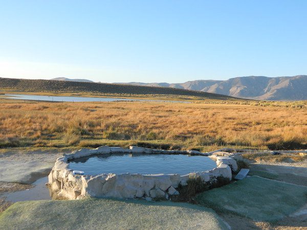
May also be known as Pulky’s Pool in hot springs books.
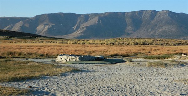
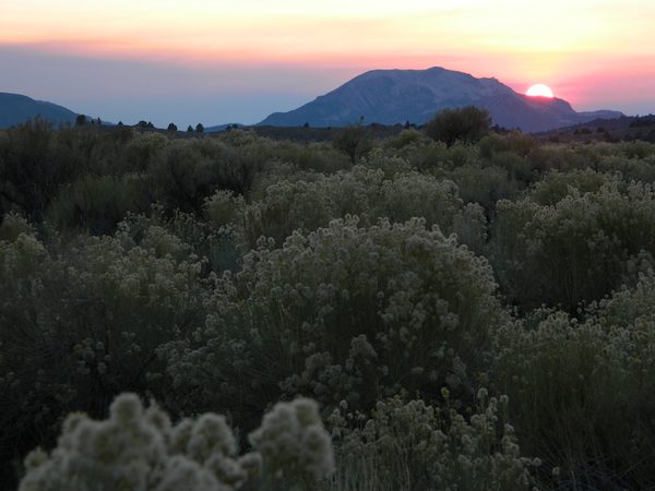
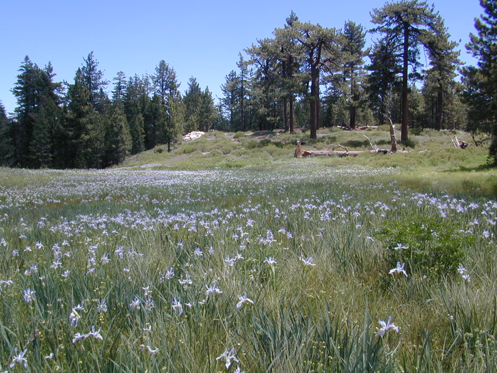
Hilltop is a new found favorite and one of the more scenic spots for a soaking tub in this region. Sitting out in the middle of a clearing, surrounded by marsh lands, this remote hot springs is a hike-in destination. No paved road, nor paved trail. The mountain and sky views from this tub are splendid, and if you time it perfect, you may have the place to yourself.
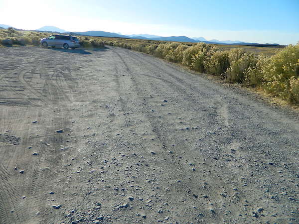
From US Highway 395 @ Benton Crossing Road – drive approximately 3 miles (passing dirt road Whitmore Tubs). Once you’ve crested a small hill, look for a gated dirt road on left, which leads a short ways, back through the sagebrush, to the parking area.
GPS coordinates: 37.6455, -118.8001
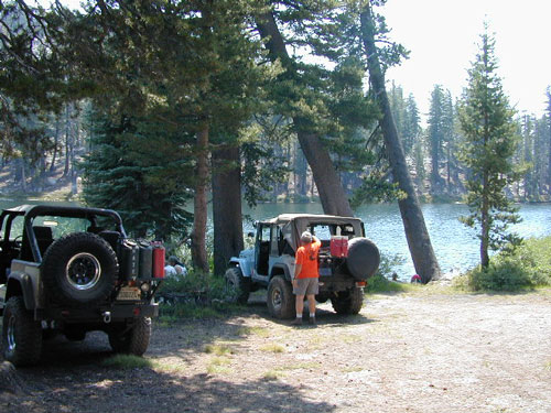
The dirt parking lot is adequate enough to handle a dozen vehicles, and this place is so well known, that it gets a fair amount of traffic at any time of year.
Rumor has it that Hilltop is one of the most visited hot springs near Mammoth Mountain; probably due to the proximity to the paved road. Cars and trucks, camper vans and RVs will be coming and going at all hours of the day and night. So consider yourself warned!
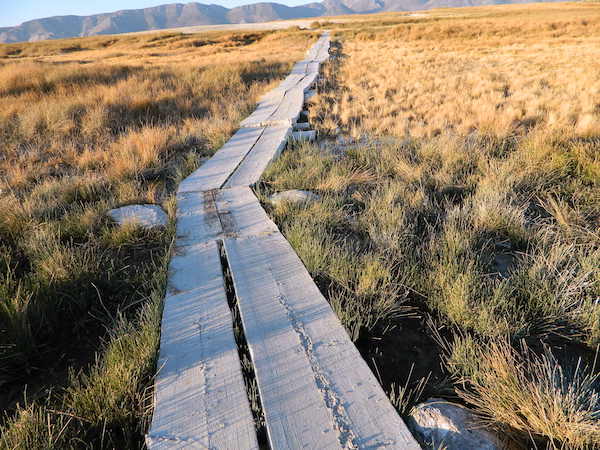
Gate and fence separate the parking from the trail, which leads a quarter mile (often over wooden plank boards) through alkali fields – out to the cement tub.
Only one, small makeshift bench next to the pool – and no tables, no seating, no facilities; Bring tarps, towels, ice chest and camp chairs (if you plan to stay a while).
Plastic PVC pipes and control valve adjust water flow and temperature. If the valve is left ON (wide open) overnight, the small tub will be too hot to soak in the following morning.
Camping options are pretty limited here. A small clearing for a tent, next to the parking lot; and one decent parking spot, large and private enough to call a camp site (at the dead end, past the parking).
The Eastern Sierra corridor of US Hwy 395 is far enough away that it cannot be heard from this spot.
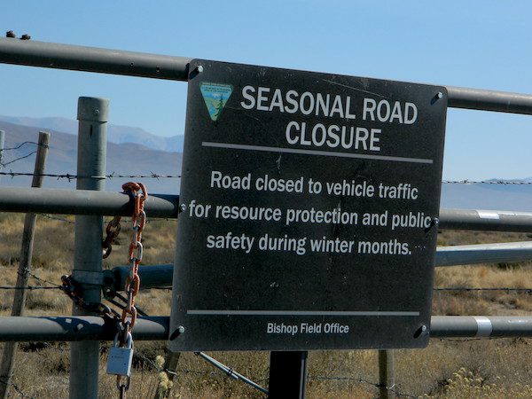
BLM gate at the paved road entrance reads: road is closed seasonally – assuming you can walk in during snowy winter months.
Hilltop is one of several primitive hot springs in this immediate region. See Mammoth Hot Springs for more choices.
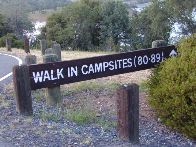
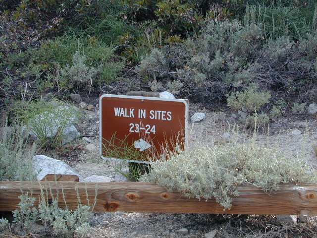
Below are developed campgrounds in California that have walk-in camp spots available. Vehicles are parked and you must carry your gear into the camp site (usually a short distance, but can be up to a half mile).
California Campgrounds with more than a 1-mile trek are not included in this list below. Areas such as – Catalina Island, Crystal Cove SP, Angel Island SP, Point Reyes National Seashore, indeed have many hike-to camps, but most are measured in miles (one way).
walk in campsites are perfect for –
people who wish not to see cars @ camp
people who prefer less noise while camping
physically fit folks, who want exercise
backpackers, who plan to hit the trails soon
avid hikers, who may be out day hiking
cyclists, just passing through
mountain bike campers
one nighters, travelers who only stay one night
late comers to the campground
(hint: these are usually the last campsites to fill up)
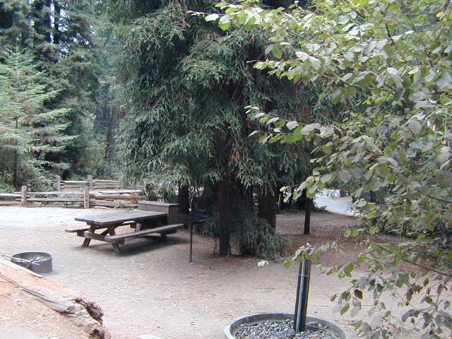
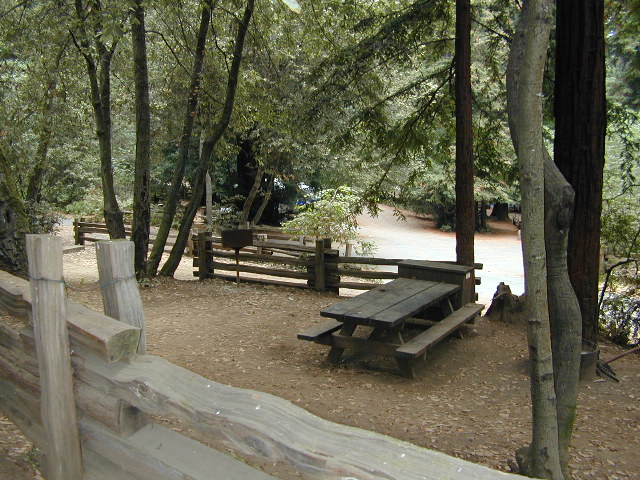
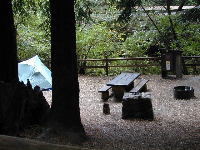
Walk in campsites are often located away from car campers & RVs. Some camp sites may have more privacy, tucked away in trees, while others have shared community area with fire pits and/or barbecues. All camp sites will have picnic tables and a some kinda toilet nearby. Bear boxes may be available for storing food properly. Sharing these food storage boxes with neighboring campers is common practice.
Campgrounds with walk-in sites range in elevation from sea level marshlands to high altitude alpine lakes. Most of these camps listed below are located inside developed campgrounds with overnight fees. Many are small campgrounds, while others are large hubs of activity. Some may be smaller campgrounds, with just a few camp sites. The most popular places can be reserved, with the links provided.
Many parks can also have day use fees, so know where you park and what time span is allowed. Ask the campground host if needing assistance. Some campgrounds lock their gates at sunset and do not permit entry at night. Others may not allow campers to check in anytime after sundown. Know their rules before you make reservations.
If you plan on not making camp reservations; make sure to have a plan B or C choice camp – in case your desired campground is already full. Many popular destinations can fill up fast (by noon in the summer).
Spacious Camp @ Aspen Grove Campground, Eagle Lake, CA
Niagra Creek Campground, OHV 4×4 trails, Stanislaus NF
North Battle Creek Reservoir, PG&E Camp, West of Lassen North Grove Campground, Calaveras Big Trees State Park
Southwest Walk-In Camp, 6700′ elev @ Lassen Volcanic NP Squaw Leap Campground, San Joaquin River, Auberry CA Stillwater Cove Regional Park, N of Fort Ross, Sonoma Coast
Table Mountain Group Camp, Bishop Creek Canyon, Inyo NF
Tahoe National Forest
Donner Area Camping Lakes
NFS 530-265-4531
Carr Lake Campground 10 miles north of Highway 20 6,700′ elev 5 walk-in campsites
Rucker Lake Campground 6 miles north of Highway 20 5,462′ elev 7 walk-in campsites
Sterling Lake Campground 9 miles north of Interstate 80 7,000′ elev 6 walk-in campsites
Toad Lake Walk In Camp, PCT @ Shasta National Forest Tuolumne Meadows Camp, Yosemite National Park
(reservations & wilderness permits required)
Walk in campgrounds are considered ‘tent camping‘, as opposed to ‘car camping‘, which is literally camping next to your vehicle. This type of hike-in camping may also be referred to as ‘trailhead camping‘, as many ideal hikes begin at these prime locations. Boat-in, bike-in or hike-in camp sites are also available at some of these locations.
Samuel P Taylor State Park
Samuel P Taylor Campground
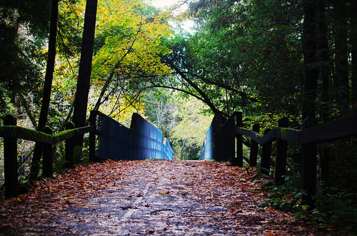
SamP is one of the large redwood parks north of San Francisco, CA. Coastal redwoods can be found in the mountains above Santa Cruz, as well as on the Point Reyes peninsula in Marin County. Hiking in the region is amazing w/ enchanted forests, dramatic fog, waterfalls, numerous trails in every direction.
One of the best developed campgrounds in the region for car camping and RV campers.
Consisting of several camp loops, a group camp site, a horse camp and hike-in or bike-in camp sites. There are even cabin rentals in the park. This park has several camp sites that can accommodate visitors with disabilities. Reservations are highly recommended, especially during summer months. Be prepared to pay hefty fees for overnight use.
Max RV Camper Length: 31′
Max Trailer Length: 27′
Creekside Loop
Orchard Hill Loop
Madrone Group Site
Madrone Cabins
Horse Camp
Hike & Bike in Sites
(8 person max)
Samuel P Taylor State Park
59 developed campsites
+ cabin rentals
Sir Francis Drake Boulevard
415-488-9897
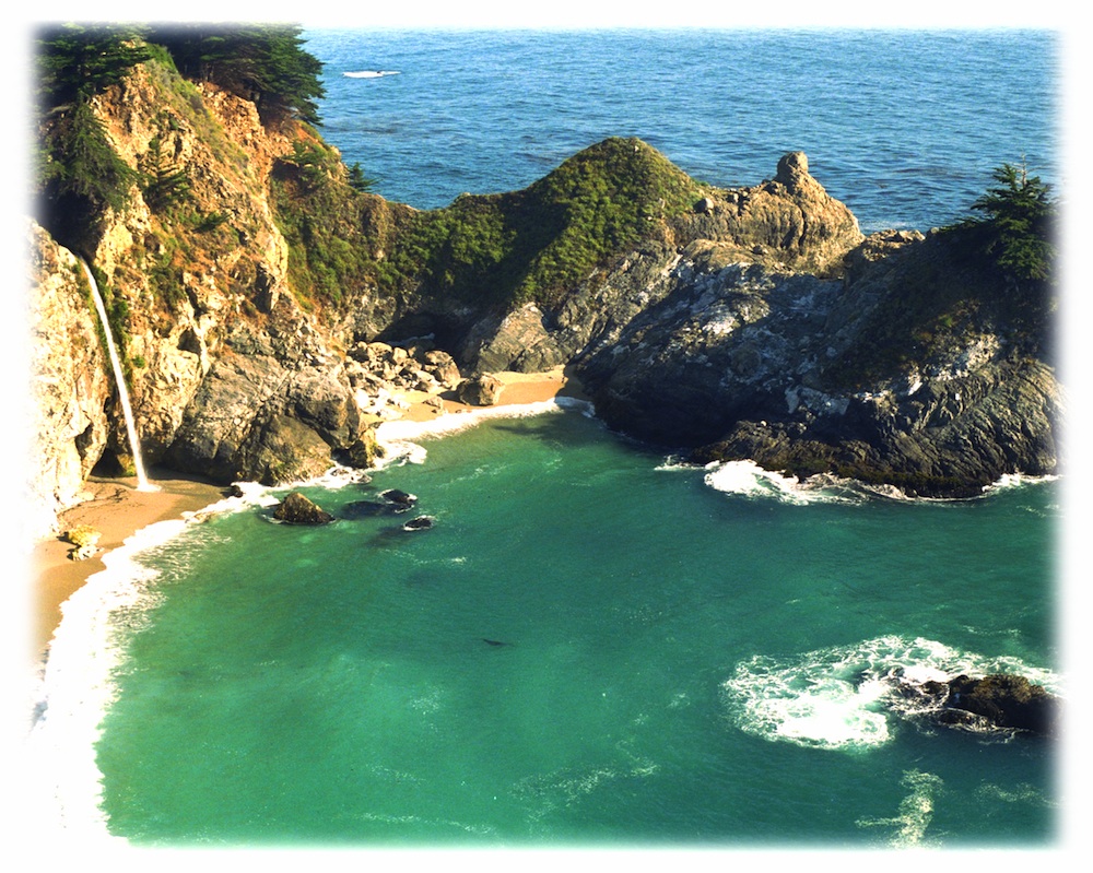
The super scenic Central Coast of California is home to numerous waterfalls, but this one on the Big Sur coast is, by far, the most well-known.
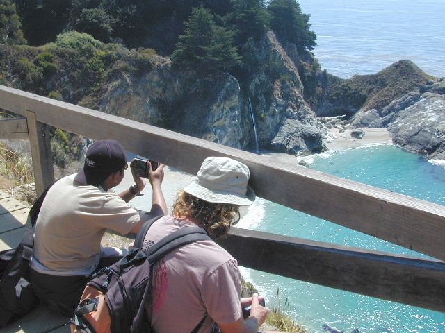
Since I camped out and slept on the cliff featured above, I thought I ought to create a post about it.
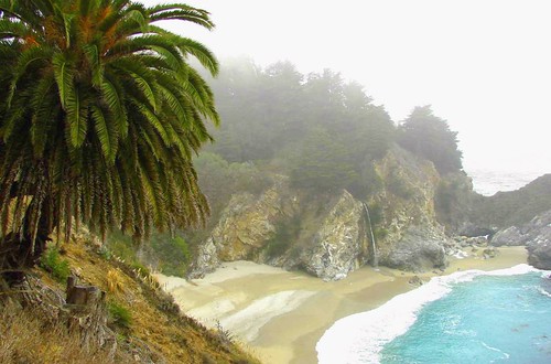
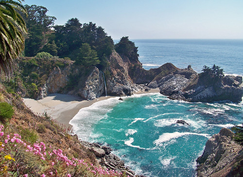
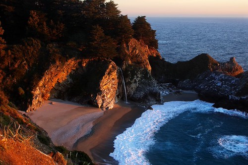
Julia Pfieffer Burns State Park is where the most photographed waterfall is located. The creek falls off of a cliff into a secluded cove, on a sandy beach just a few feet from the Pacific Ocean.
After visiting this place more than once, I knew I had to keep coming back. I even found this waterfall photo used as graphic marketing for Mexican Riveria cruises, by Costco.
But it’s not located in Mexico, nor Baja.
McWay is Big Sur!
One sunny autumn day, I called my camping pals to join me on our pre-planned camping trip to the majestic Big Sur coastline. Not just any camping spot or campground, but the two rare, hike-in campsites – located above McWay Falls. The camp reservations had been made months in advance and I was eager to leave the smog basin of L.A.
One by one, all my friends backed out of their commitment to camp that weekend. Too busy at work, a wedding or other plans interfered, home improvements, or the typical lame excuses that city folks always use not to travel locally.
…only 2 camp sites exist here, perched on a forested cliff, overlooking a private sandy cove w/ a gorgeous waterfall
I thoroughly explained to them the spectacular scenery, the unique location, the advanced reservations and fees, and the carpooling options. But not one person could go, so I went anyway.
All alone; which may have been the start of me craving to camp solo (way back in 1995).
The California State Park system has named these as environmental camps, where you must haul your gear – a half mile, on foot, in order to reach these special campsites. Picnic tables and campfire rings are provided, along w/ one vault toilet. Although a real bathroom w/ flush toilets is within walking distance, over at the main paved parking lot.
INACCESSIBLE:
The picturesque sandy cove is off limits to all = campers, hikers and climbers. New fencing and signs warn visitors not to enter the small beach cove area. Sheer, steep cliffs w/ erosion are unstable and dangerous; and you may have a citation awaiting you, on your climb back up.
Accessing the cliff edges or private cove is dangerous and difficult, and totally off limits. If you wanna die trying, that’s up to you.
OVERNIGHT TIPS:
Reservations are needed to camp at this location. Contact California State Parks for booking this spot.
The ocean sounds of crashing waves on rocks is very, very loud. located just below (100 feet) the ideal camp sites. Bring ear plugs for sleeping.
Leave food and cooking to the tailgate. Parking in the paved, forested parking lot, and not transporting food, ice chest and cookware back and forth is the lazy way. Since I was camping alone and the parking lot was secluded and full of vegetation, I decided to try minimal food at camp. Worked well for me.
Blackberry bushes are abundant around parking lot.
PANCAKES ANYONE?
Danger looms around this State Park entrance, as Coast Highway 1 drivers tend to speed by at 55 mph, on a big shady curve. Be very careful crossing the road at this location and listen for traffic before you walk.
TRAILS & DAY VISITORS:
Swarms of tourists stop at this location, just to walk out, photograph and view this waterfall. Many pay top dollar (day use) to park and then stay less than an hour. The tunnel trail goes past a pelton wheel and then underneath the highway – skirting along the north shore of the cove. The State Park gate closes at sunset, so very few people will be found roaming around after sundown.
Just hiking around this park, plus the back and forth to camp and car will feel like you’ve walked many miles. There is a redwood canyon and creek hike located in the inland portion of the State Park. Mountain peaks here reach to about 3000′ elevation.
AUG 2020 UPDATE: WILDFIRES burning most of this State Park and Limekiln State Park. Not sure how the cove looks now, or if it was affected, but expect the hills to be black, up above the highway.
Julia Pfeiffer Burns State Park
52801 CA State Route 1, Big Sur, CA 93920 831-667-1112
If there is a single most popular image of Big Sur, it is probably of the 80 foot falls seen from this trail as McWay Creek cascades onto the sandy shore. hikinginbigsur.com/hikes_mcwayfalls.html
Even though I spent the warm weekend alone, camping on a waterfall cliff and hiking redwoods forests, I enjoyed myself and the seclusion. I did meet 2 surfers traveling in a vintage VW bus and they joined me for my tailgate dinner one evening. On the last night, the weather turned windy and a storm came in, so the next morning I was happy to leave. So, for all the camping pals that backed out at the last minute, this 2020 post is for you.
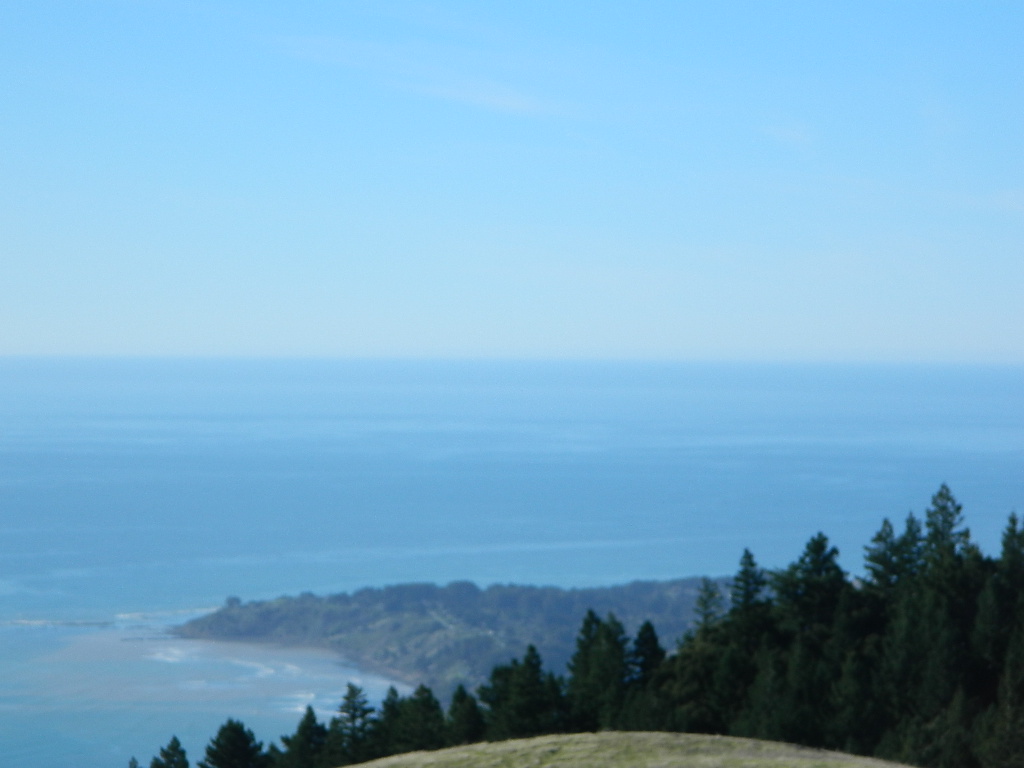
One of the most visited coastlines in the world, San Francisco – where 2 peninsulas almost meet – at the mouth of the “hidden bay”.
This is the Golden Gate to California and the Wild West.
So, you wanna escape the tourist masses… and camp out, overlooking an amazing place?
(put on your hiking boots)
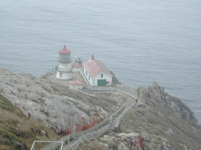
Pt Reyes Lighthouse
Nope, the Lighthouse doesn’t have a campground! There are no camping facilities at Muir Woods National Monument, nor Muir Beach. No camping at Stinson Beach, nor Bolinas.
The Tule Elk Reserve has no camping at all. Tomales Bay State Park no longer has car camping or RV camping available; hike-in or boat-in
camping, maybe.
What is available for campground camping on “the Point” is listed below, with phone numbers and links for more info.
Cycling, hiking, backpacking, mountain biking, kayaking and boating are all popular outdoor recreation activities.
Small towns located on the Point Reyes peninsula do have a few private campgrounds, some of which can accommodate motorhomes. Follow towns links for those.
There are no RV parks, camper trailers or motorhomes allowed in campgrounds on the steep coastal region of Point Reyes. Most of the narrow, winding roads are forbidden for motorhome travels. No shoulder, no guard rails, on many curvy roads. Great viewpoints are best when you STOP to look, off the roadway.
Often called fly fishing lakes, or backpacking lakes, these are usually located in the mountainous parts of California. Remote lakes that are ‘hard to reach’ come in 2 varieties:
hike-in lakes
Backpacking Lakes, found in the Sierra Nevada Wilderness or Northern California Wilderness Areas.
These are often many miles down a dirt road or narrow paved route (neither which is recommended with a big trailer or large motorhome). Matter of fact, some of these lake destinations require 4 wheel drive to access them. You will need a good vehicle, maps, possibly more than one. You will need time to enjoy these. They require a fair amount of work to get to, but the rewards are immense.


 If you plan on not making camp reservations; make sure to have a plan B or C choice camp – in case your desired campground is already full. Many popular destinations can fill up fast (by noon in the summer).


 Max RV Camper Length: 31′
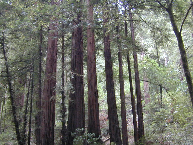


 The Tule Elk Reserve has no camping at all. Tomales Bay State Park no longer has car camping or RV camping available; hike-in or boat-in