Forty-something years running, this San Diego county desert 4×4 event is one of the most popular off-roading weekends. Tierra Del Sol, a local 4 wheel drive club sponsors this wheelin fest in Southern California.
This one is a huge deal in the Los Angeles area. 4×4 extremes – in every direction. Tons of offroad industry vendors, displays, demos, and custom rigs and hot chicks in skimpy shirts for your viewing pleasure. Drool over every suspension, roll cage and locker. Lucas Oils is the big sponsor and this event is held annually, Family Events off road expo, summertime, air conditioning, in gorgeous Pomona.
San Luis Obispo County Off Roading
Los Padres National Forest
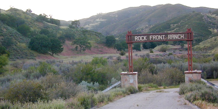
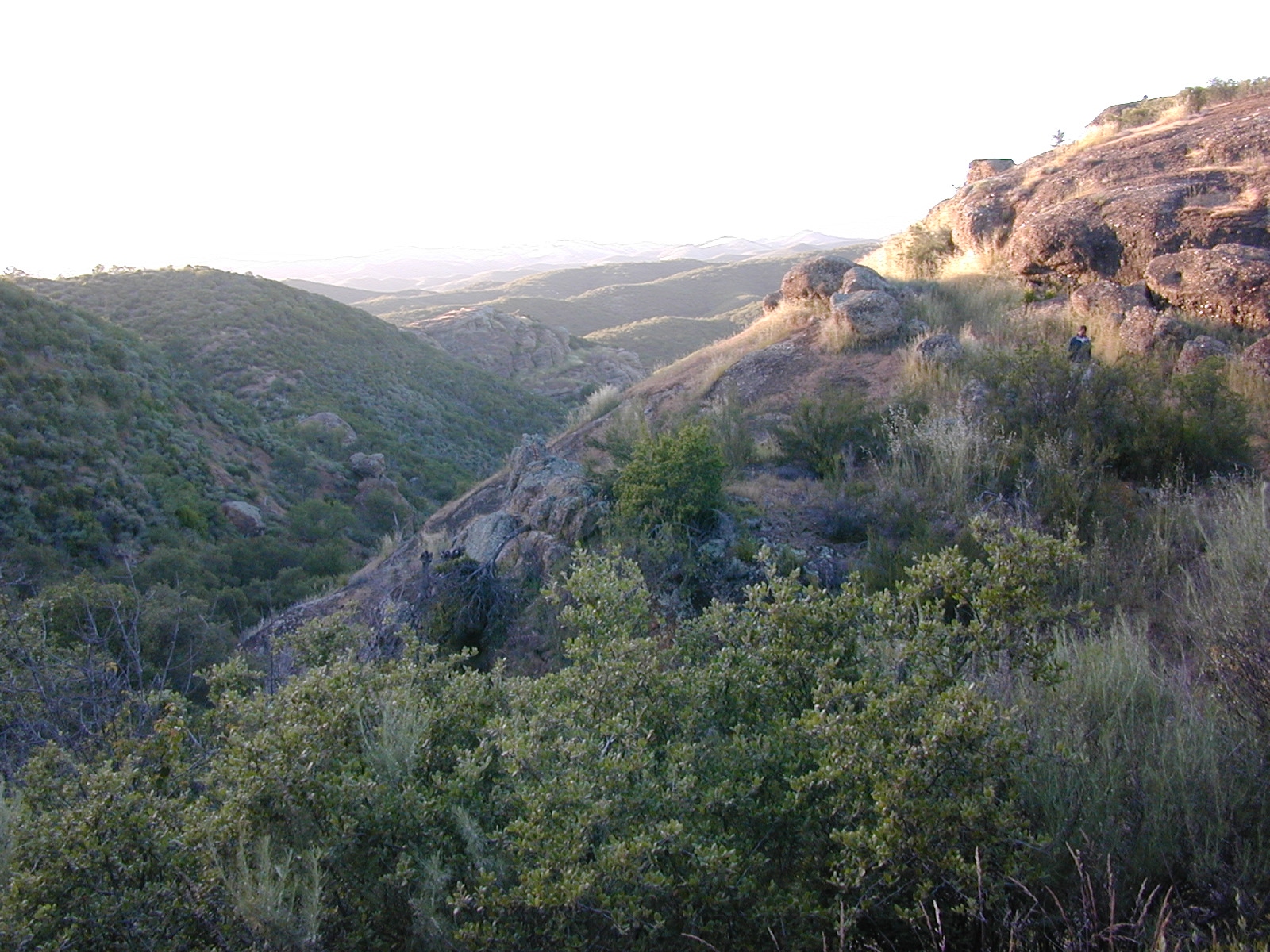
Rock Front Area is located on the north side of Hwy 166 in between New Cuyama and Nipomo, on the very edge of San Luis Obispo county in the center of the Santa Lucia Ranger District of Los Padres National Forest. Landscape varies from rock covered canyons to ridge line trails with outstanding vistas of the the mountains and Cuyama Valley. Remote area features Los Machos Hills, Alder Creek, Branch Creek, Cuyama River, cool rock formations.
15,328 acres
41 miles of trails
From US Hwy 101 @ Hwy 166 travel east 25 miles, left turn into Rock Front Ranch gate on left side. (This road may also be known as Branch Creek Rd on some maps). This off road area can be closed during rainy seasons, so it is best to call rangers ahead of time to ensure the gates are open. There is also one brown Forest Service sign along highway 166, (couple of miles from 101) letting eastbound traffic know if this OHV area is open or closed.
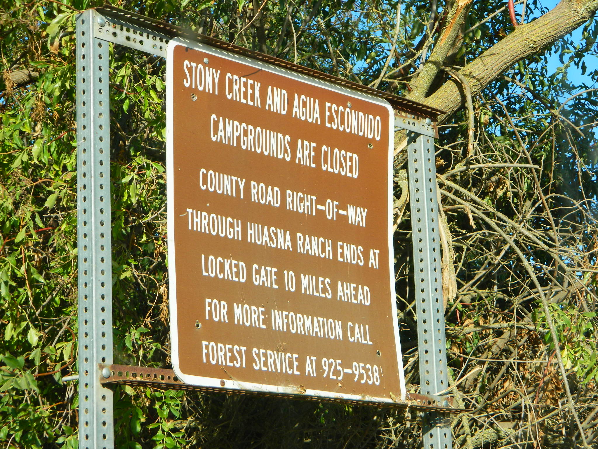
The dirt Road #32S07 (Arroyo Seco) from the west connecting historic Huasna townsite to Rock Front is CLOSED to thru traffic and has a locked gate. Private properties and ranches are abundant in the backcountry of Arroyo Grande, CA
OHV trail ratings in this region are designated below
Green diamond – easy & least difficult
Blue diamond – moderate & more difficult
Black diamond – extreme & most difficult
Logan Ridge Trail #17E05
Green diamond. Least difficult. Open to motorcycles, ATVS, 4WD. 1.4 miles long. This route is a good route for beginning riders. It is located on the main ridge top of Logan Ridge. Route dead-ends at a locked gate.
Shaw Ridge Trail #17E06
Black diamond. Most difficult. Open to motorcycles, ATVS, 4WD. 8 miles long. This route leaves the Twin Rocks route on a spur ridge that drops into the Alamo Creek drainage and dead-ends. A very steep section of trail exists at the end of this route where specialized equipment is recommended. This section is recommended for advanced riders.
Los Machos Trail #17E07
Green diamond. Least difficult. Open to motorcycles, ATVS, 4WD. 2.8 miles long. This route is a good route for beginning riders. It is located on the main ridge top of the Los Machos Hills. Route dead-ends at a locked gate.
Paradise Trail #17E08
Blue diamond. More difficult. Open to motorcycles, ATVS, 4WD. 2 miles long. Access to Paradise Campground and Los Machos route. It is best suited for intermediate riders due to a steep section along the route. Route dead-ends at a locked gate.
Branch Creek Trail #17E09
Blue diamond. More difficult. Open to motorcycles, ATVS, 4WD. 5.5 miles long. Access to Buck Springs Campground, parallels the Big Rock route and offers a loop ride.
Big Rocks Trail #17E10
Blue diamond. More difficult. Open to motorcycles, ATVS, 4WD. 4 miles long. Located on the main ridge top and intersects with the Jack Springs route.
Twin Rocks Trail #17E12
Blue diamond. More difficult. Open to motorcycles, ATVS, 4WD. 3.5 miles long. This route intersects Shaw Ridge and dead-ends at a locked gate. The first half-mile of this trail is steep. Once on top of the ridge you have excellent views of the Cuyama Valley and the Santa Lucia Range.
Kerry Canyon Trail #30W02
Black diamond. Most difficult. For motorcycles only. 6 miles long. This trail must be accessed through Colson Canyon or Sierra Madre. The trail is highly technical and is recommended for advanced motorcycle riders only.
HORSE TRAINING – Along the highway at the gate of Rock Front Ranch is a rock house and ranch, which may or may not offer equine services.
Small campgrounds and secluded camps, accessible by dirt bikes or 4-wheel drive vehicles. Numerous dirt roads, sand dunes and canyons to explore, some with developed campgrounds, other areas w/ primitive camping. Self sufficient campers will enjoy this list.
4×4 camping in California
Okay, you got your 4 wheel drive vehicle dirty, it is now several years old & maybe you even have a scratch or two. Now is the time to finally start using that beast for real off road adventures. The real edge-of-wilderness trips you dream about when your sitting in your cubical wondering what life is really about. Fishing, camping, off roading and enjoying nature, of course!
4×4 camping in California is plentiful. California has trails for OHV use – which means ‘off highway vehicle’, that can accommodate your machine. These remote camps are always primitive camp sites, with picnic tables, fire rings & maybe a pit toilet (if you are lucky). You can find total seclusion on these back roads & trails, well away from the developed campgrounds & RV parks.
Anza Borrego Desert 4×4 Trails – pretty much everywhere in Borrego desert is off road heaven. Minimal pavement and maximum desert means dirt roads galore, white sandy washes, slot canyons, badlands, wind caves, wildflowers, petroglyphs, boulder outcroppings, old railroad trestles and so much more. The San Diego desert elevations range from near sea level to 4000′ on the eastern slopes of Laguna Mountain.
San Bernardino National Forest – has a few trail camps for 4×4 enthusiasts. John Bull Trail (near Holcomb Valley) has one real awesome camp spot with great views over the desert night lights. Holcomb Creek Trail also has a few spots near the creek. Overall this area is somewhat crowded for wheelin’ (especially on the weekends), as the population is so dense nearby.
Los Padres National Forest – the most 4×4 camping, readily accessible to Southern California. This is truly the best kept secret for Angelinos wanting an escape. The southern portion of the forests has Tecuya Ridge #9N22, with several camps only minutes from I-5. Cherry Creek 4×4 Camp, with a few other campsites tucked way back in there. Dome Springs Campground is located off Lockwood Valley Road, while Nettle Springs Campground is over near Highway 33.
Out west, Cerro Noroeste Road has the Blue Ridge w/ Marion and Caballo Camps. Red dirt high desert wash Quatal Canyon #9N09, is right next to the Chumash Wilderness.
2 OHV parks in the Los Padres Area: Hungry Valley & Ballinger both serve the off road crowds and have ample facilities, large camp spots to accommodate RVs and trailers.
The northern section of Los Padres (near Big Sur) has plenty of dirt roads & primitive camps, but none are truly 4×4 routes, as most can be accessed easily with a passenger car. See more on Big Sur Camping and Big Sur BackRoads.
Sequoia National Forest– Southern Sierra Nevada area has 4×4 camping right along the Kern River @ Keyesville, at the junction where Hwy 178 meets Hwy 155. Also, further up the river, Forest Rd#22S82 leads to primitive Camp 4, where there are several spots near granite pools, that can only be accessed by 4 wheel drive. The Big Meadows area also has some gorgeous forested back roads worth exploring. Kern Plateau has hundreds of miles of OHV trails near Troy Meadow.
High elevation Monache Meadows is a prime fishing & hiking destination on the south fork of the Kern River, accessed by an authentic “Jeep Road”.
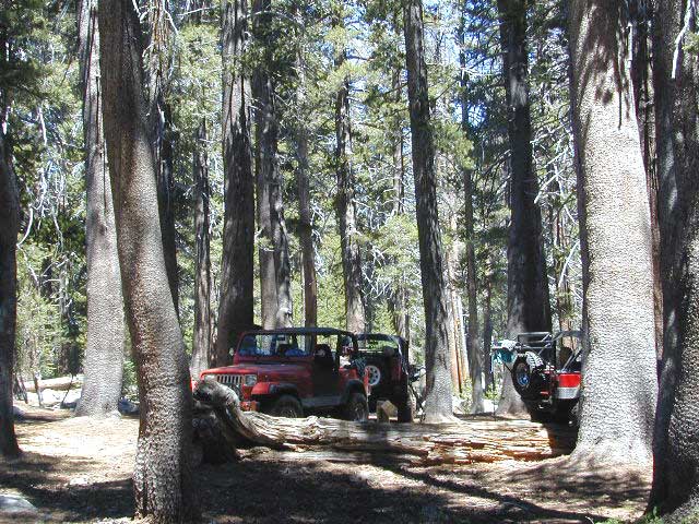
Sierra National Forest– central Sierra forest has plenty of 4×4 routes that lead to granite rock gardens & mighty fine, secluded, forested camp sites. Gorgeous Red Lake & Coyote Lake are popular spots that require some technical skills & much patience to access. Both are frequented by fishermen & horses. Bald Mountain trailhead has awesome creekside camps on Rock Creek. Up near Wishon Reservoir is the dead end trail of Spanish Lake. Onion Springs Meadow is awesome back behind Edison Lake. Near the granite wonderland Courtright Reservoir is the infamous Dusy Trail signed #28E34 (aka #7S32, the Dusy Ershim), second only to the Rubicon Trail for high Sierra granite.
Stanislaus National Forest– camping in the Crandall & Niagara Creek OHV section of the forest, right off Hwy 108. Elevations range from 5000′-7000′. Higher up on the other side, Levitt Lake (access road near Levitt Falls) on the east end of the mountain range, east of the Sonora Pass sign.
El Dorado National Forest – has an area called Rock Creek for off roading in the Gold Country. Plus the ever popular Rubicon Trail starts hear (near Georgetown) & leads 20 miles across the High Sierra Nevada granite slabs to Lake Tahoe. Tons of camping back here in the National Forest.
Lakes Basin Recreation Area – Northern Gold County, just above the Yuba River. Gold Lake has many campable lakes. The area sees a lot of snowmobile traffic during winter snows, but warmer months are the time for fishing and camping. Most of the big lakes have small developed campgrounds, some are minimal, or primitive style camp sites on dirt roads without facilities. Maybe a picnic table at most.
Smith Lake is a place that fishermen and 4×4 enthusiasts love. It is small, secluded and kinda hard to find. You’ll need a good topo map of the region. Situated on the border of Tahoe and Plumas National Forest off the Gold Lake Hwy (aka Road #24). The PCT cuts thru this Lakes Basin area w/ Sierra Buttes There are dirt roads and off road trails leading deep into the backcountry from the Packer Lake and Gold Lake areas. Snag Lake is a free camp right on the main road.
Snake Lake Campground has numerous dirt roads and trails leading out to Butterfly Valley. Horse campers use this popular camp spot, so no loud vehicle activity inside the campground. No shooting up the bear locker either!
Milsap Bar is a long, narrow 9 mile dirt road which leads from Bald Rock Road in Berry Creek, down to the Middle fork of the Feather River. NFS Campground on the big river without fees!
China Gulch Road #60, a very long and winding dirt road, leads from Oro-Quincy Highway down to the Little North Fork. Although the NFS Campground is closed due to a landslide (1 mi before camp) there still is primitive camping at the second bridge. Be warned: the campsite at the first bridge is often over run with giant, juicy slugs at night.
Out there east of Quincy, somewhere off the historic, long and winding La Port Road, a few decent 4WD trails thru forest, access ridge lines or the big river below. Great fishing, amazing scenery & very secluded.
(north of La Porte Road)
– Feather River access
@ Cleghorn Bar Campground, 4 campsites (Road #23N24)
@ Stag Point Campground, 5 campsites (Road #22N80Y)
@ Hartman Bar NRT to Dan Beebe Camp (Road 94 to #22N42Y)
(south of La Porte Road)
– Poker Flat Camp near Sawmill Ridge & Table Rock (Road 800)
Sly Creek Reservoir is a super popular NFS Campground with trailheads and dirt roads leading deeper into the forests. The camp area is a favorite amongst the off roaders and dirt bikers that migrate up to the mountains for the weekend, to escape from the heat of the summer in the Sacramento Valley. LGVR is another body of water back in these parts and is more scenic and peaceful than the Sly Creek.
This coastal range is dirt road heaven, graded dirt roads, ridge routes, hiking trails, equestrian trails, big lakes, small lakes, creeks, meadows, forests, wilderness and 4×4 routes. Snow can be the most fun and challenging for the 4WD crews. Mud, snow, some road closures seasonally.
2019 WILDFIRE: Ranch Fire – wiped out most of this area. South of Snow Mountain Wilderness, plenty off road trails leading to peaks and ridge lines. Numerous small campgrounds to choose from, trailheads everywhere, acres and acres of wild mountainous areas, and a lake resort nearby. Lake Pillsbury is kinda the center of all the 4×4 action in Mendo.
Fouts Springs – Numerous NFS Campgrounds catering to the off-road types a portion of the year, but mostly quiet other times.
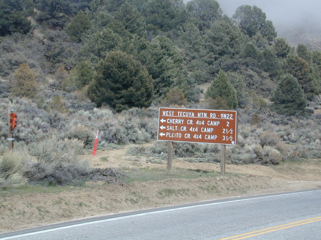
Tecuya Mountain 4x4camps, Los Padres National Forest
4×4 Camps @ Tecuya:
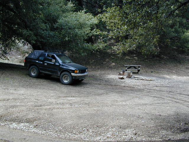
Cherry Creek Camp
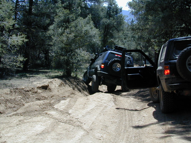
Seeking a dark shady hole to spend the night? Then Cherry Creek canyon is choice for a quick overnighter near Frazier Park and the I-5 Tejon Pass. Steep dirt road access will challenge even the biggest skeptic.
free campsite
4WD only access
The 4×4 Camp (signed) turn off is along Cuddy Valley Road, on the north side of the pavement – just a few miles west of Frazier Park, inside Los Padres National Forest.
Oak trees and brush clog the dense hillsides. Owls live in this canyon. Deer and wildlife sightings are common – which makes this an ideal hunters camp for those looking to explore on foot.
The canyon gets narrower as it heads down hill (northward) w/ the single track route becoming a blanket of slick dark mud (in the wet months). Without trees on the worst section, making a self-rescue impossible.
Real 4 wheel drive is needed for this camp! All wheel drive vehciles (SUV & sportwagons) should not attempt this location without a tow strap or winch – AND another 4WD vehicle to help out. Yep, seriously. We know, because we had to rescue someone last time we were here.
Sparse accommodations w/ minimal sunlight reaching this steep canyonHigh clearance and articulation is a must.
Dirt roads, backroads, desert trails, OHV routes, single tracks, dunes, fire roads, gravel roads, 4×4 roads
When you wanna explore a new area, California has plenty of public land to offer. Off Road Maps can get you away from the crowds & the main staging areas. Maps can show you prime areas to ride & camp that you may not have ever imagined. Secluded, wide open, or freeway close. Terrain – the endless deserts, the mountain foothills, the higher hills , way above the city. The choice is yours.
Whether you seek secluded stream side camp sites, with some fishing or a dusty, long, desert trail that spans the entire Mojave desert, you can find these secret spots with good old fashioned topographic maps. Hard copies! The real deal. No cell signal? No problem.
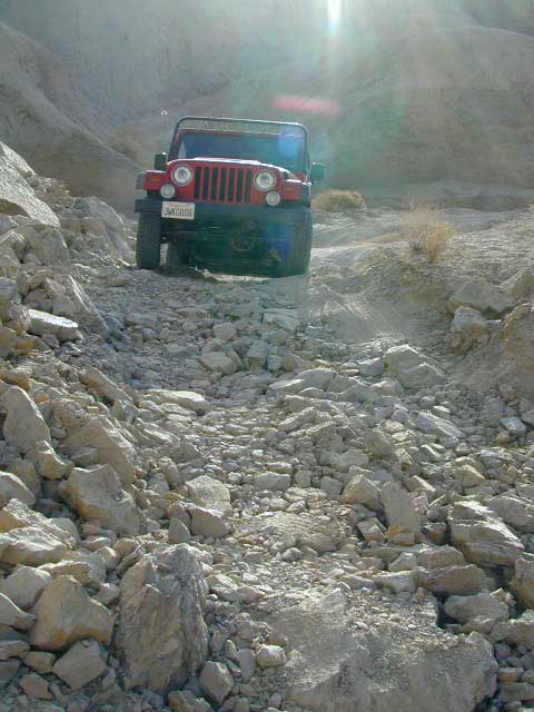
4×4 Panamint Valley has numerous canyons & ridges to conquer
The most trusted full-state book-atlas that Total Escape recommends. When you must have a (hard copy) map for local road trips – Benchmark Atlas is the best one by far.
NFS, USDA
Forest Atlas: National Forest Topo Atlas
Spiral bound book of all topographic quads, of select National Forests in California.
Awesome California locations w/ off-road trails nearby. DanaMite has compiled a list of first-hand knowledge information, links, photos, campsites, maps, all revolving around rural California. Check out the ever growing list and get ready to explore the back roads, like never before.
OHV area, motor vehicle use, 4×4 camps, dirt trails, forest routes; Download maps for various off-roading areas in California.
What the heck is it ???
4WD = 4 wheel drive
4×4 = (same as above)
2WD = 2 wheel drive
4×2 = (same as above)
AWD = All wheel drive
SUV = Sport Utility Vehicle
MTB = Mountain Bike
MX = Motocross (dirt bike motorcycle)
SNOMO = Snow Mobile (sled machine)
GAS-POWERED RECREATION: The past two decades have emerged with vehicle redesigns from well known brands, creating a number of new “utility vehicles” for the sport of off-roading (otherwise known as, burning gasoline while recreating in the outdoors). Here is a breakdown on the acronyms, but they all basically refer to much of the same “off road type vehicles”.
ATV = All Terrain Vehicle (quad)
MOHUV = Multipurpose Off-Highway Utility Vehicle
ROPS = Roll Over Protection System
ROV = Recreational Off-Highway Vehicle
RUV = Recreational Utility Vehicle
SxS = Side by Side Vehicle (2 seated)
SSV = (same as above)
UTV = Utility Task Vehicle
Common abbreviations for off-road on public lands:
OHV – Off Highway Vehicle SVRA – State Vehicular Recreation Areas BLM – Bureau of Land Management NFS – National Forest (USDA) MVUM – motor vehicle use map (NFS)
PVT – private land / keep out
MTR – motorized
RD – road
CO – county
RTE – route
SR – state route
FR – forest route / road
EXT – exit
CK – creek
EL – elevation
MT – mountain
STA – station (ranger/fire station)
PO – post office
Around 2012 the National Forest Service printed up a bunch of nice off-road maps for various popular regions of California. Oddly, they told me not to sell them and I never heard anything about them again after that. Not even sure if these above are available to the public, but if you dig around you might find ’em. Call the rangers, they might know.
If interested, you could call the ranger station and ask about any local off-road maps, and availability. Mostly they have freebie one page print-outs, black & white — to keep the crowds where they want them. Other times they might have real color, printed maps for sale at the station. Maps that can get you deeper into the terrain, with wild edges of reality nearby. 4×4 maps, OHV map, MVUM
BLM Maps (Bureau of Land Management)
Government agency that manages large amounts of California land. Public lands that do not fall into the National Forest or National Park or State Park realm. BLM oversees some mountain areas, river canyons and primarily, desert regions within California. Visit a local BLM office to see the selection of area maps.
Turtle Mountain Road
Decent & FREE: dirt road maps can be found at BLM ranger station, south of NEEDLES, on US Hwy 95. Explore Turtle Mountain and find free camping IN ROUTE; Eastern California Desert.
Fortunately, those places do not allow driving on the dunes, which is exactly what the off-road boys want to do. Sand flying, motors screaming, music blasting, bon fires blazing and no silence found until the wee hours of early morning.
Autumn, Winter & Spring are the busy months for ‘froaders in the deserts, since summer temps can soar into triple digits heat daily.
Camping out near “the dunes” is usually a big, freaking, free-for-all, outdoors with the latest in motorized toys. Recreation Vehicles encircling bonfires (camp formation for a large group), toy box haulers, trailers, families, and maybe a massive BBQ setup.
OHV (off highway vehicle) Vehicular Recreation Area
California BLM Desert Sand Dunes
Below is a list of California Sand Dunes overseen by the Bureau of Land Management.
Arroyo Salado / Ocotillo Wells
Motorcycle, 4WD, ATV, Dune Buggy / Sand Rail
Located 10 mi. west of Highway 86 on Highway 78. Rolling hills and sand washes. Designated “Open Area” consisting of 4,800 acres. Adjacent to Ocotillo Wells Vehicular Recreation Area. Near Split Mountain, Anza Borrego Desert
Dumont Dunes Mojave
Motorcycle, 4WD, ATV, Dune Buggy / Sand Rail
Located 30 mi. north of Baker on Hwy 127, off Dumont Dunes Rd. Steep and tall sand dunes. Designated “Open Area” of 8,150 acres. South of Death Valley National Park.
Dumont w/ the Saabaru AWD
Glamis / Gecko Road
Motorcycle, 4WD, ATV, Dune Buggy / Sand Rail
Holiday weekends = NUTS!! Approximately 22,000 acres. Located 25 mi. east of Brawley on HIGHWAY 78. Sand Dunes. Designated “Open Area” Danger: Adjacent to military bombing range. Contact the El Centro BLM
Imperial Sand Dunes / Buttercup Valley
Motorcycle, 4WD, ATV, Dune Buggy / Sand Rail
Approximately 11,000 acres. Located 10 mi. southeast of Niland on the Niland Glamis Rd. Sand Dunes are designated “Open Area”. Watch for closed area boundary at south end of area. CA Highway 78 near Brawley. Contact the El Centro BLM
Mojave El Mirage / Shadow Mountains
Motorcycle, 4WD, ATV, Dune Buggy / Sand Rail
Located 10 mi. west of Adelanto on Crippen/El Mirage Road. Dry lake Bed. Heavy use area. many non-motorized and motorized recreation – including aircrafts. Area consists of 24,000 acres.
Plaster City / Yuha Basin
Motorcycle, 4WD, ATV, Dune Buggy / Sand Rail
South side of Anza Borrego Desert State Park. 15 mi. west of El Centro. Located on county Highway S-80. Consists of 41,000 acres of rolling hills and desert flats. Military bombing range north of area is closed to entry. Contact the El Centro BLM
Superstition Mountain
Motorcycle, 4WD, ATV, Dune Buggy / Sand Rail
Located 15 mi. NW of El Centro via Highway S-8, Huff, and Wheeler Roads. Varied terrain consisting of 13,000 acres; dry lakes, badlands, rocky mountains, and sand dunes. Military bombing range north and south of area is closed to entry. Contact the El Centro BLM
Rasor OHV Recreation Area
Motorcycle, 4WD, ATV, Dune Buggy / Sand Rail
Located 45 mi. northwest of Barstow, CA on Rasor Road. Sand washes and dunes, mesquite thickets. Designated “Open Area” consisting of 22,500 acres. Contact theBarstow BLM
Rice Valley Dunes
Motorcycle, 4WD, ATV, Dune Buggy / Sand Rail
Located 5 mi. south of Rice Valley off of Highway 62. Access is Santa Fe Road. Sand dunes. Designated “Open Area” consisting of 3,770 acres. Area of little use. Danger: Contaminated with unexploded ordinance.
The mysterious topographic map maker, Landon Crumpton, is gone. Although his Baja Almanac book of the Mexican peninsula is still as popular as ever.
The Total Escape crew has been using this amazing topo map for Baja Mexico since our the very first excursions in 1990. Click below to read more about the famous, hard-to-find Baja Almanac publication.


