Tag Archives: trail map

El Dorado Camping

Primitive Camping in El Dorado County

Camping Rivers

More & more people are venturing off the beaten path. Tourist flocks to Gold Country, and many do not even leave Highway 49. Get up the mountains, higher than the foothills.camp

Getting outta the developed campgrounds to discover the joys of dispersed back woods camping is a new adventure, not to be taken lightly.

With truck or SUV ownership come some great rewards! Order a good map & go find some dirt roads. Waterfalls, dense forests, secluded creekside camp sites & more await you. Obtaining a camp fire permit is mandatory for this style of camping.

campfire

fish

Campfires are often banned in California, due to extreme wildfire danger. Since the gold mining foothills are usually oak and dry grass, with large steep river canyons, extra caution should be given. Always know the fire conditions before you build a campfire. Caldor Camping

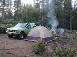
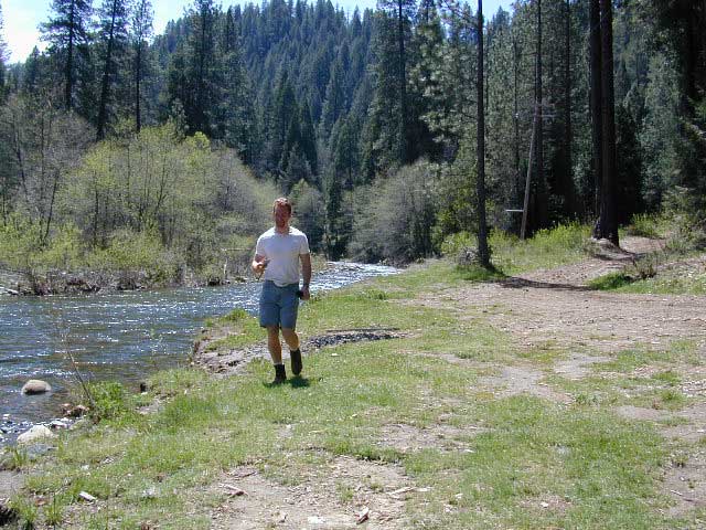
Discover the hidden back roads: like Caldor Road off of Grizzly Flat Rd. – above Placerville CA

Hey, now this is what we’re talking about. Plenty of great dispersed camping down by the Cosumnes River & Consumnes Mine Rd. There are hundreds of miles of small roads to discover back behind this historic mining area. Rivers, waterfalls & decent fishing too. Make sure you clean up some litter. This is the only price you pay for the beauty, serenity, peace & quiet & no neighbor campers next to you.

hiker

Out exploring these parts, you may run into a dead end road that peters out at some Private Property, which is usually signed & fenced. Make nice with the old crazy miner dude & turn your ass around politely, everything will be okay as soon as you are not within gun shot of him. Yes, there still are plenty of small time mining experts tucked away back here in the hills.

river camping
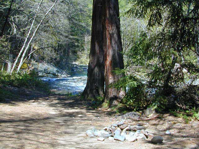
Premium and secluded river side camp sites in El Dorado National Forest

Plenty creeks and rivers run throughout this central Sierra region, so you can fish all day – until your hearts desire. River rafting and river kayaking opportunities are also great reasons to get wet.

canoe

Several mountain reservoirs around offer camping and boating too. Eldorado lakes are listed below.

  • Caples Lake @ Carson Pass
  • Ice House Reservoir
  • Jenkinson Lake – US Hwy 50
  • Kirkwood Lake
  • Lower Bear River Reservoir – South Shore Campground
  • Salt Springs Reservoir
  • Silver Lake @ Carson Pass
  • Union Valley Reservoir

mountains

nearby towns –

El Dorado Forest Maps –

Central Sierra Nevada Mountains

Small Camping Lake
Kirkwood Lake Campground

Central Sierra Nevada: Sequoia to Donner

Although Sequoia trees can be found in the southern Sierra, the National Park is located more in the mid-Sierra. From the Kern River to Kings River,  the southern stretch of Sierra Nevada is home to the southern most Sequoia groves, the longest river in California, and the granite dome wonderlands that overlook the Mojave Desert.

The Tehachapi range is on the tail end to the south w/ Hwy 58, while Kings Canyon Park borders more High Sierra Wilderness to the north end. If you are heading up from SoCal, this is the most accessible portion of the Sierra Nevada range.

While the Kern River Valley can get hot in the summer months, the rivers, streams & higher elevations surrounding it, make it a prime destination for folks seeking cooler mountain breezes, creeks and dark skies. Springtime is one of the best times of year to visit the Kern River. While summer is best for the high wilderness areas, since the snow usually doesn’t melt until May.

Mountain Home State Forest is a little known haven for campers & hikers seeking less-crowded Sequoia groves. With the Tule River, fishing ponds, waterfalls, swimming holes & meadows, this place provides a nice solitude to the busier parks to the north. Balch Park is a county park w/ large campground, that sits adjacent to Mountain Home Forest.

Both National Parks (Seqouia & Kings) are both busy in summer & tourists can be seen lining the main road, Highway 198. Crystal Cave & Boyden Cavern both offer daily tours during the warmer months. Sequoia National Park is open during winter months & is popular among winter sports enthusiasts. Kings Canyon National Park & Hwy 180 are also open during winter, with winter sports recreation.

Big Meadows Road (14S11) offers great camping options for those that wish to camp outside the National Park boundaries.

Sequoia groves

Sequoia forest & parks –

Sequoia National Forest
Mountain Home State Forest
Sequoia National Park
Kings Canyon National Park

Sequoia maps & trails –

Sequoia towns nearby –
Alta Sierra, Camp Nelson, Fairview, Kennedy Meadows, Kernville, Lake Isabella, Mineral King, Ponderosa, Springville, Three Rivers, Wofford Heights

Sierra Nevada

Central Sierra Nevada forest & parks –


Sierra National Forest

Yosemite National Park

Stanislaus National Forest

Eldorado National Forest

Tahoe National Forest

Sierra Nevada

Central Sierra Highways –

Central Sierra Nevada maps & trails –

Rancheria Falls
Rancheria Falls, Huntington Lake, CA

Central Sierra Nevada towns nearby –
Bass Lake, Fish Camp, Huntington Lake, Pine Flat Reservoir, Shaver Lake

stanislaus sonora pass

Gold Country California

is located in the western foothills of the Central Sierra Mountains

Historic Highway 49 is the Gold Country Hwy, which begins down near Yosemite and leads north, thru the foothills, up to Sierra Buttes & ends out near Loyalton, CAgold miner

Dirt Street

7S02 up hill

An avenue made of dirt, earthen highways, dirt trails, forest roads, fire roads, jeep road, graded roads. Dirt driving trails that lead into the middle of nowhere. No stop signs, no billboards, no stores, no one else around… for miles. Enjoy less crowds and more open space.

dirt streetsIf you are fed up with city life, sitting in traffic & need to vacate your mind among the barren hills of California (if only for a weekend), then Total Escape is your place. You seek solitude, peace, maybe a mini tailgate party & BBQ on a dry lake bed, with the heavenly stars above. Imagine the warm camp fire light reflecting off the high canyon walls, your music echoing, moonlight hikes for a few miles.

California has some awesome spots to drive on dirt, get way back in nature. Right up to the edge of the Wilderness boundary. That’s what this one silly “dirt street” page is all about… helping you get out there, the easiest & best way possible. We even got you the right maps!

Back Roads in California

The End of Dirt Roads

California OHV Maps

Most of this is just dirt road driving, graded, some hills, easy stuff. But on occasion you might come across a 4×4 required sign – or perhaps a triple black diamond trail. Having several good maps on hand will help you enjoy these roads, instead of stressing & wondering if there is a lock gate at the other end – 18 miles in.

Some dirt streets lead to campgrounds, some to waterfalls, some to viewpoints, some have loop options & others are just dead end; sometimes at old mines. Get ready to explore with your truck or SUV. 2WD or low clearance vehicles (such as passenger cars) should be ready to turn back if the road get too nasty. Any decent precipitation can make any unpaved road much worse & may require 4 wheel drive, so have a plan B mud terrainor C as a backup idea.

Best off road areas & parks in California:

Death Valley Roads

Tooling around Goler Wash & Barker Ranch on the very edge of Death Valley

California Camping Maps

California Campground Maps

Maps are the key to finding your very own slice of heaven in the Wilderness. Online map sources can barely get you to your city destination correctly, much less the remote waterfall you desire. You will need a real map for your adventure. A topographical map, with all the details, dirt roads & hiking trails. If you are seeking to stay away from the touristy crowds, this is the best possible place you can be…. on this site, searching for ways to make it happen – this weekend.

BACKPACKERS BACKPACKING MAPS –

maps of California
Mount Whitney, John Muir & way beyond the High Sierra. DanaMite has all the California Wilderness maps on the new map shop. Various brands and types of maps. Most are printed on waterproof plastic now & are tear-resistant.

CAR CAMPING MAPS –

El Dorado Camping
Planning on camping outside of the developed campgrounds & finding that perfect stream side spot without the reservation & the fees? Then you will need a free fire permit (from a ranger station), plus a good map of the forests & a vehicle capable of handling the rugged the back roads. Much of California is prone to wildfires, so make sure campfires are even allowed on the backroads, before you get out there. Call the “field rangers” for back road advice and current recommendations.

CALIFORNIA OFF ROAD MAPS –

Wanna take that 4×4 vehicle somewhere really special this season? Camp well beyond the masses, way down that dirt road. We have OHV maps for SoCal, the deserts & all the National Forest maps too.

CALIF CAMPGROUND MAPS –

Start your search on the perfect campground or camp site with the destination in mind. Mountains, deserts, coastal. Parks & forests all have their own maps with all nearby camp grounds listed. We feature all the National Forest maps, as well as some State Park & National Park maps

See all California topo, hiking, camping maps

Sierra Nevada maps

coolsprings

  • California A to Z
  • California Camping
  • California Elevations
  • Camp Firewood
  • Camp Potty
  • RV camping deep in the Sierra
    RV camping at it's best in the Sierra; This rig found themselves deep in the alpine lush meadows with towering trees and a view and a very private camp site.
    Big Bend CA
    Big Bend Ranger Station, off I-80

    John Muir Wilderness

    John Muir Hiking / John Muir Map

    High Sierra Hiking

    California Wilderness Area Acres Topographical Maps
    John Muir Wilderness

    elevations: 4000′-14,496′

    584,000 John Muir Wilderness Maps
    Inyo National Forest

    JMT

    High Sierra Nevada / Eastern Sierra

    Rugged Sierra Nevada high country. The highest peaks in the Sierra Nevada mountains can be found inside this Wilderness. Many peaks are well above 13,000 feet. Granite, glaciated basins, big snow, alpine lakes, meadows, wildflowers, streams, creeks, cliffs, jagged peaks. Mount Whitney stands as the tallest mountain in the lower 48 states.

    John Muir Trail Maps
    – JMT Topo Map

    lacontedivide
    Le Conte Divide, Sierra Nevada California – 12,000′ elevation peaks

    Eastern access via steep granite hiking, off US Hwy 395 (Bishop, Independence, Lone Pine)
    Western access backpacking thru Kings Canyon National Park, Hwy 180
    or Sequoia National Park, Hwy 198 (Mineral King, Three Rivers)
    or Sierra National Forest, Hwy 168 (Lake Edison, Florence Lake, Courtright Reservoir)
    North access via backcountry Yosemite National Park, Hwy 120
    or Mammoth Area towns (Lee Vining, June Lake, Mammoth Lakes)

    Hundreds of miles of hiking trails, some of the highest peaks in the nation. Trails open to equestrian and foot traffic only. Trailhead quotas limit the amount of day hikers and backpackers that an access the Wilderness daily. Wilderness permit required: Inyo National Forest Permits

    Eastern Sierra Visitor Center
    Inyo Visitors Office

    JM Topo Trails

    USDA National Forest
    USFS, NPS, BLM

    NFS NPS

    Eastern Sierra Interagency Office
    US Hwy 395 @ SR 136
    Lone Pine, CA 93545
    760-876-6200

    JMT
    JOHN MUIR TRAIL- John Muir Wilderness

    nearby towns, parks & resorts:

    Aspendell
    Big Pine
    Bishop, CA
    Courtright Reservoir
    Florence Lake
    Independence, CA
    Kings Canyon National Park
    Lake Edison
    Lone Pine, CA
    Mammoth Lakes
    Olancha, CA
    Tom’s Place
    Wishon Reservoir
    Yosemite National Park

    www.flickr.com