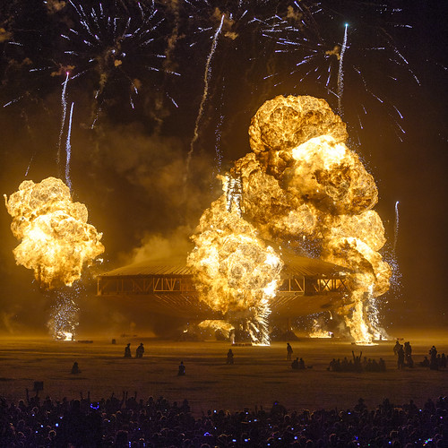
Everyone (who is anyone) has heard of this massive annual desert party by now. The historic bon fire event that started in Santa Cruz in 1986 and then moved out to the deserts of Nevada. Way north of Reno!
The event is getting bigger by the decades, so expect a mind altering experience with tens of thousands of well-decorated lost souls. Advanced tickets are required.
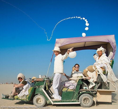
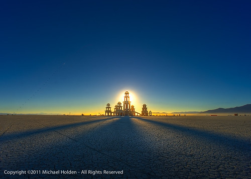
Art cars, construction, costumes, pyrotechnics, live bands, music DJs, the playa dust & summer desert camping w/ 70,000 other freaks in the temporary set up of Black Rock City.
BRC = Black Rock City
NPR said about Burning Man, “Once considered an underground gathering for bohemians and free spirits of all stripes, Burning Man has since evolved into a destination for social media influencers, celebrities and the Silicon Valley elite.”
Starting in 2014 Death Valley National Park announced that there will be NO sporting events of any kind held within Death Valley National Park, so this particular event has been relocated to the high desert region of Reno, Nevada
Claimed as the “Toughest 48 hours in Sport”, a 508-mile bicycle race revered the world over for its epic mountain climbs, stark desert scenery, desolate roads, and its reputation as one of the toughest but most gratifying endurance challenges.
*NOTE: moved from the month of October to September
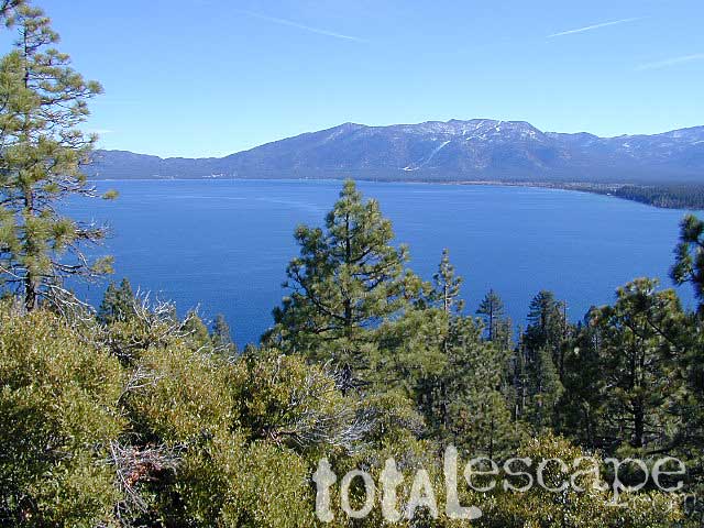
Lake Tahoe California One of the most popular Sierra destinations – be it summer or winter, Tahoe sure is crowded these days.
Below are all the developed campgrounds surrounding beautiful Lake Tahoe, CA. Most of these are located near the lake or, on the Truckee River. Most accept campground reservations in advance. blue links lead to camp info
All Tahoe Campgrounds charge a fee; Many require advanced reservations. Nightly rates vary per park. Most campgrounds are closed during the winter due to snow. Check with the ranger districts listed here.
Bowman Lake
Tahoe Forest
Tahoe National Forest encompasses a larger region of the Sierra Nevada mountains surrounding the north portion of Lake Tahoe. American River, Yuba River, Northern Gold Country; Plus many small lakes with excellent forests, including Lakes Basin Recreation Area.
Blue Lakes has several campgrounds, south of South Lake Tahoe.
Below are Tahoe Campgrounds located away from the Lake Tahoe Basin; Most small camps are on a first come, first serve basis. blue links lead to camp info.
The lands surrounding Las Vegas are NOT managed by the NPS, National Park Service – but Lake Mead is considered a National Recreation Area. Hoover Dam is located at the south end of Lake Mead, then the Colorado river connects further down stream to Lake Mohave.
Tourist are no longer burdened by the constant flow of traffic over the dam, because a beautiful, new bypass bridge has been recently built above the dam.
Boating, kayaking, fishing, hiking, off-roading and camping are popular attractions at both the reservoir lakes. Mohave Lake is lesser known and therefore, less crowded. 4×4 may be need to reach certain coves at Mohave.
Most of the public lands in this Vegas desert are managed by BLM or the USDA National Forests. The Great Basin National Park is located in central Nevada, nearly 300 miles NW of the city of Las Vegas.
Lake Mohave on border of California, NV & AZ
Red Rock Vegas
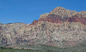
Some folks know these rock walls as Red Rock Canyon, or Red Rock Park near Vegas – but the official name now ‘Red Rock Canyon National Conservation Area’ and the lands are managed by the BLM.
The closest red rock park to Las Vegas, this one is located at the far west end of Charleston Blvd. – an easy exit to find off the freeway Interstate 15. Day hikes, rock climbing, mountain biking, picnics and a large BLM campground. This desert range can get very windy and the only campground around is poorly located along the busy highway, on a ridge. Bring good tent stakes and be prepared for serious wind. Better camping options can be found over at the higher elevation Mount Charleston, see below.
Vegas Valley of Fire
This beautiful desert park is 60 miles N of Vegas and well worth the day trip to explore native petroglyphs, hike among red rocks, sandy washes and just relax to take in breathtaking vistas. See more about the Valley of Fire State Park
Mount Charleston Camping
Several developed campgrounds are available in a pine forest setting. Some may charge a nightly fee, or a day use fee. Mary Jane Falls is well worth the hike. Two lodges grace this mountains, The Mount Charleston Resort is the big log and stone cabin along a straight away on Kyle Canyon Road #157. The Mount Charleston Lodge is above at 7717′ elevation and has a popular restaurant and nice modern mountain cabin rentals.
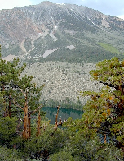
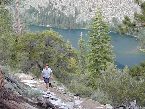
small, scenic, hike-in only lake (pictured below).
1.2 mile hike downhill – strenuous, very steep; 800′ elevation loss. Bloody Canyon trailhead also connect to Sardine Lake, above Walker Lake.
There is also another Walker Lake in Mendocino County California. Walker Creek, Ridgewood Park; west of US Hwy 101, south of Willits, CA
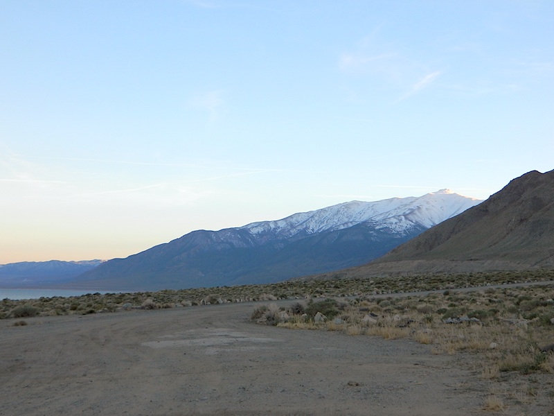
Mount Grant, Nevada
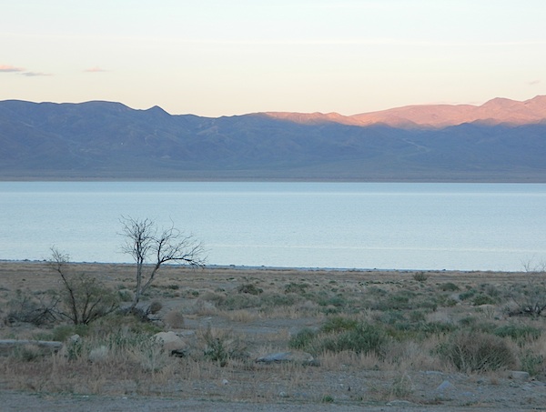
Walker Lake, Nevada
very windy, Walker Lake, Nevada
US Highway 95, north of Hawthorne, NV
Mount Grant elev. 11,239′
Walker Lake State Recreation Area, now known as Monument Beach, is located along the western shore of the lake. The Hawthorne Army Depot, the world’s largest ammunition depot, fills the valley to the south of the lake. Naval Undersea Warfare Center?
Route 95 passes along western shore of Walker Lake. Walker River from the Eastern Sierra mountains in California, may sometimes flow into Walker Lake, Nevada.
Upstream water users have exploited the Walker River for profit, resulting in the destruction of Walker Lake, NV. According to the USGS, the level dropped approximately 181′ between 1882 and 2016. By June 2016 (under drought conditions) the lake level was 3,909′ above sea level, the lowest lake elevation since measurement began in 1882.
Mojave Reservoir @ Colorado River: AZ / NV / CA
@ the V, bottom of Nevada state = Arizona – Nevada – California, all merge together
The Colorado River travels through the southwest desert, splitting the Grand Canyon and further south, separating California from Arizona at the southern tip of Nevada. Agriculture lines the big river down to Baja, Sea of Cortez, Mexico.
Up near Las Vegas and down to Searchlight, NV
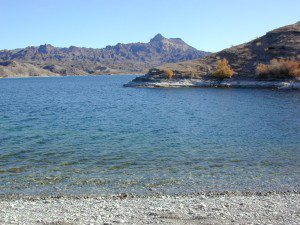
Above Hoover Dam is Lake Mead, sediment from Utah National Parks. Red dirt and silt shorelines. South of Hoover dam is a super deep rock gorge w/ hike-in hot springs. Beyond that, this beauty called Lake Mohave – with the super clear water, secluded coves and abundant fishing.
Lake Mohave: elevation 647′
Desert peaks in this region are around 2000-3000′ elevation. Mohave Lake is actually a wide section of the Colorado River, spanning the region from massive Black Canyon south to busy Laughlin w/ river casinos. This lake is long and skinny in spots with lots of shoreline cliffs, canyons and coves. Minimal vegetation, so please bring your own firewood and don’t chop down the few trees trying to survive. Summer temps exceed 100 degrees, so plan your visit for the winter time.
Lake Mohave Ranger Stations
Cottonwood Cove
Katherine Landing
boating, camping, fishing, hiking, hot springs, kayaking, off-road, picnics, viewpoints
El Dorado Canyon Road, main paved route can be accessed near California’s state border. North of Searchlight, Nevada – off main highway 95, on side route 165 to Nelson, NV
Secluded dirt roads up and down canyons near El Dorado Canyon Rd. Minimal vegetation, maximum open scenery and dark skies. Kayak rentals @ El Dorado Canyon.
desert badlands erosion
Ireteba Peaks Wilderness
4×4 camping routes: 15 day camping limit
Find your own route with many to choose from, drive the soft sandy washes (with a few boulders to dodge) and camp for free, right at the waters edge. Adventurers: Only for the self-contained campers. Some routes marked 4WD only, so pay attention to signs. AWD (all wheel drive) vehicles should fare well on the sandy roads; but standard passenger cars and vans will need to keep their speed up in the soft sand areas.
No garbage collection. Pack it in, pack it out.
No facilities, no fees. No buildings. No campfire rings, no picnic tables, very few vault toilets. Bring your shovel!
Driving off the roads is strictly prohibited. Primitive camp sites can be found both at numerous coves and also inland inside the canyons. The ridges get windy in the deserts, but are favorable for night sky views and self contained camper vans.
Always know the weather forecast, cuz flash floods are possible and these dirt roads will be impassible during big rain. This is the main drainage to the big river!
DRIVING TIPS
Most desert washes here are signed routes 4×4, but mini vans, AWD sport-wagons, trucks, SUVs, small RVs can all be found camping near Lake Mohave. That is – if you know how to ‘drive off road’, which is not fast, but not too slow either.
Avoid getting stuck in the deep sand: keep speed up, do not turn sharply and do not brake hard. Carry tow strap in case you need an emergency pull. Be nice to strangers and you may find help.
Campfires are allowed, but you need to bring firewood. Dogs are allowed. Party animals tend to trash these desert coves, so be warned that there is a fair amount of litter. Bring a black trash bag and take some out! This trash problem could get the area closed off to vehicles so keep that in mind.
The canyons here have giant power lines that cross @ Aztec Wash; they can easily be avoided.
4×4 recommended @ MOHAVE:
Eagle Wash Road #46 – popular spot
Montana Wash #45 – camping ok
Placer Wash #47 – no camping
The rangers don’t wanna be pulling your ass out of the sand, which is why they post the 4×4 signs. Don’t expect to find help without walking a few miles first, or waiting several hours.
desert wilderness
Several wilderness areas are located along the west side of this lake & river. Often dirt roads will parallel a portion of the wilderness boundary, providing excellent access to secluded coves and beaches. Emergency CALL boxes are placed in remote parts of these shores.
Ireteba Peaks Wilderness (northwest, next to El Dorado Canyon)
Nellis Wash Wilderness (western side)
Spirit Mountain Wilderness (southwest)
Bridge Canyon Wilderness (southwest, near Laughlin)
COTTONWOOD COVE
developed campground, boat launch, marina, lodging, hiking, picnic areas
LAUGHLIN, NV
Nevada, California and Arizona states join down in this part of the world. Katherine Landing, full service marina, slip rentals, lodging, city services and casinos.
Mojave Desert – This river-created lake is located on the Colorado River, in between Las Vegas, Nevada and Needles, California. The river water here is crystal clear, very swimmable and the fishing is decent. No paved boat ramps
nearby towns: (with elevation)
Avi Casino
Bullhead City, AZ (540′)
Laughlin, NV (535′)
Kingman, AZ (3340′)
Needles, CA
Nelson, NV (2954′) Nipton, CA (3042′) Oatman, AZ
Searchlight, NV (3470′)
Desert camping south of Reno? Well there ain’t much to choose from out here. Walker Lake near Hamilton, NV looked dismal, so keep driving northbound and hope for the best.
Maybe one of the canyons near the reservation has a level pull out along the highway. Just far enough off the main road to hear the midnight traffic, just barely.
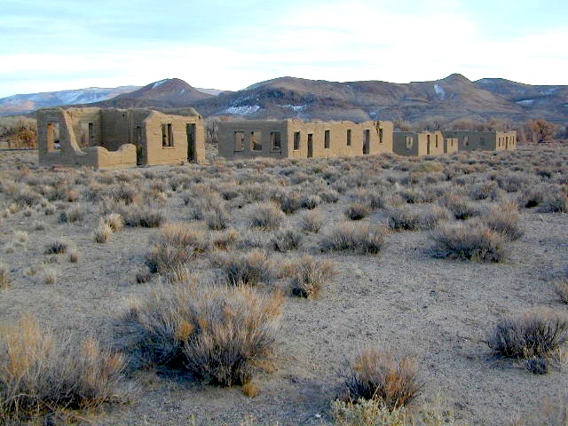
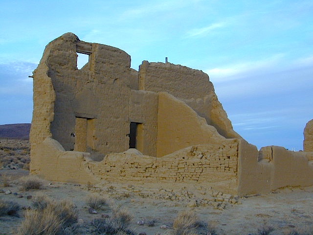
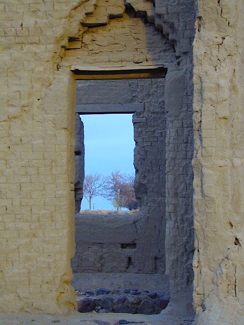
Fort Churchill, Nevada
Fort Churchill was one of the original US Army forts built to help with the flood of overland pioneers making their way to California. Adobe structures in ruin, plus the sagebrush wetlands and cottonwoods along the river make for ideal scenery. A Pony Express route too!
Shall we call it the first of the California Welcome Centers?
Or an invasion of the “wildness” of the Sierra Nevada, and the West Coast.
From the year 1800 on – trappers, hunters, miners, ranchers, prospectors, surveyors, homesteaders – and basically everyone was headed westward, across the continent. The secrets of the golden state were unfolding worldwide. After gold & silver were discovered in the hills, the real rush to Alta California began.
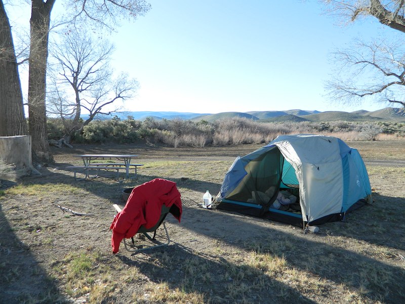
Ideal “in route camping” if traveling near Reno, south of Interstate 80. You gotta be off on the side route through Yerrington, Nevada to reach this convenient road side campground. Big trucks stick to the main highway, but this rural 2-laner cuts thru residential, reservations, and ranch lands. Rural backroads are abundant and most are private property.
Driving on rural Nevada Highway 95A you can find the park headquarters and fort on the west side of the road. The camping is on the opposite (east) side of the highway, down an embankment, near the Carson River. A very small brown sign with the word CAMPING (reflects at night) and you may see it – if you aren’t driving 70 mph.
DESERT CAR CAMPING – VEGAS TO RENO
Perfect refuge for weary travelers, along the long, lonely, desert highways of Nevada. RV campers will like the wide dirt road w/ some level spots, accommodating the largest of motorhomes w/ dump station nearby. Trucks w/ trailers are often seen sleeping along the roadside at this location. Equestrian river access w/ horse trailers too.
Cottonwoods in some of the lower spots, but mostly sage brush, rabbits and open skies. This is the Carson River Basin, so dirt roads w/ mud and potholes are common. No street light near here. In the dark, the primitive roads are manageable, but the signs are minimal.
elevation 4250′
SNOW is minimal in WINTER months (DEC-MARCH)
Desperate tent campers (willing to drive dirt for a bit) can find the “scout camp”. Most nights are filled with the cries of the coyotes in the distance. Park rangers patrol in the morning to collect camp fees. Or you can find the park headquarters, across the highway.
NO CAMP RESERVATIONS
Primitive campground has 20 sites suitable for travel trailers, motor homes or tents. Campsites include a table and fire ring, w/ camping limit of 14 days. Group camping is also available.
Mt Charleston cabin rentals, vacation homes and 2 mountain lodges are located near the Spring Mountain Recreation Area, just outside of the Sin City limits. The tall alpine mountains behind RedRock SP, NW of Las Vegas, Nevada are virtually unknown by many non-locals. Great hiking, mountain biking, camping and waterfalls, plus a small seasonal ski and snowboard resort are some of the highlights. Imagine snowboarding Vegas!
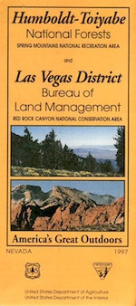
Vegas means “the meadows”, but it sure seems more like desert these days. The forest is just up the hill, past the red rock and tract homes, well past the Joshua Trees. Conifer forests, snow and high elevation, less than an hours drive from the Vegas strip. Toiyabe – Humboldt NF is this public land managed by the US National Forest system. Toiyabe also covers Eastern Sierra slopes. Get California Toiyabe NF maps. Get the Nevada State Park map here!
Camping Vegas
Due to extreme dry conditions and wildfire danger no open camp fires are allowed from mid-April to mid-November in the Mount Charleston region. Several developed campgrounds, plus a primitive (dirt road) camp area off Lee Canyon. Cabin rentals are located at the Charleston Lodge.


 One of the most popular Sierra destinations – be it summer or winter, Tahoe sure is crowded these days.
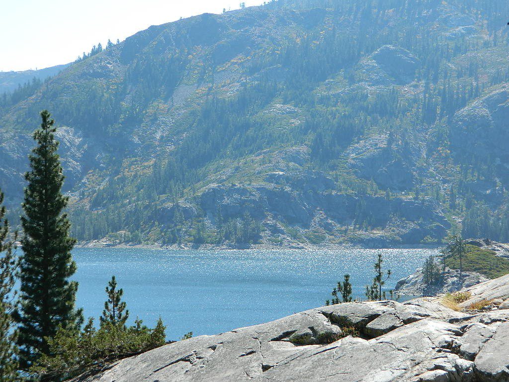


 Lake Mohave Ranger Stations