Great Overland Stagecoach Route of 1849 San Diego County Rd S2 San Diego County Highway S2
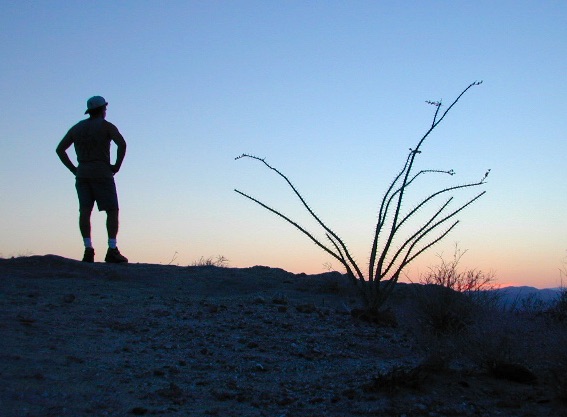
The awesome southern California desert, a stretch of road that traverses north-south direction on the west side Anza Borrego Desert; from Interstate 8 up to to Lake Henshaw @ San Felipe Road. Driving north you gain elevation from sandy badlands into the mountains, but trees are few and far off. Exit I-8 at 400′ elevation above sea level and gradually climb to 3000′ – over near Lake Henshaw & Palomar Mountain.
San Diego Road S-2 is about 50 miles long, through very scenic desert with interesting vegetation and paved the whole way. Perfect for RV travelers, as it has many camping options – from freebie, primitive camp spots to private campground resorts. Palm canyon hide-aways, secret shady spots, endless hiking canyons, and a campground with hot springs.
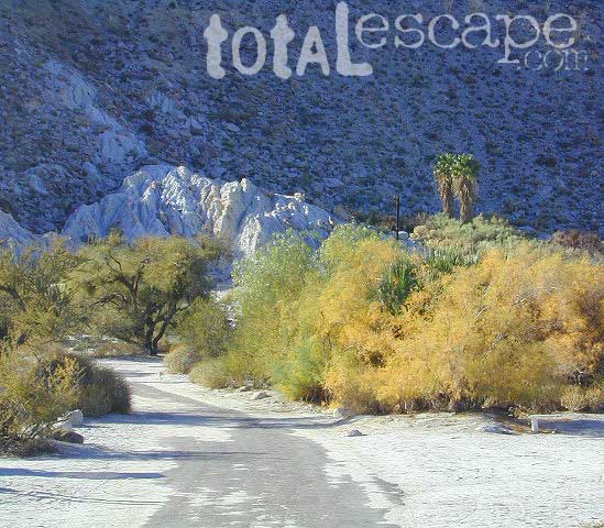
S2 Road intersects California SR 78 at Scissors Crossing and continues north through the barren San Felipe Hills. The Southern California portion of the Pacific Crest Trail parallels the ridge line on the east side, with the town of Borrego Springs lying behind that ridge at 590′ elevation. The historic mountain town of Julian sits in the hills above Banner Grade (Hwy 78).
Anza Borrego Desert State Park & Borrego Springs Campgrounds
Anza Borrego Desert is the largest of the California State Parks. Borrego Palm Canyon Campground is the official name of this popular palm oasis & developed campground located very close to Borrego Springs CA. Hike or bike to town. There is also a private RV Park named Palm Canyon Resort in town, just to confuse you.
Desert wildflowers blooms, popular hiking & biking trails, plus mud caves & slot canyons draw plenty visitors here, mostly in the winter months. Summer high temps exceed 90 degrees for months at a time.
There are hundreds of miles of dirt roads to explore, and one could easily spend every weekend for a full year, checking out all there is to see in this vast desert, where elevations range from near sea level to 5000′ peaks.
BORREGO PALM CANYON CAMPGROUND
main campground near Visitors Center, in town Borrego Springs, CA
120 camp sites for tents & RVs, flush toilets, overnight / day use fees reservations accepted
TAMARISK GROVE CAMPGROUND
27 camp sites, flush toilets, fee
on S-3 @ Highway 78 jct (closed June – Sept) reservations accepted (Oct-May)
Vern Whitaker Horse Camp
equestrian campground w/ corrals, 10 camp sites, flush toilets
elev, 960′, located N of Borrego Springs, near scenic and rugged Coyote Canyon. reservations accepted
Backcountry Campgrounds Anza
Arroyo Salado
16 miles east of Borrego Springs on County Road S-22
Blair Valley Camping Area
open car camping & RV spots, vault toilets
on SAN DIEGO County Rd S-2 near Highway 78 jct
Bow Willow Campground
elev, 950′, hwy access, 16 camp sites, pit toilets, overnight fee
near Sweeney Pass & badlands overlook; located on S-2, 9 miles N of Interstate 8
Canon Sin Nombre
off S-2 near Sweeney Pass; entrance near Badlands Overlook; slot canyon hikes
Coyote Canyon Camping
N of Borrego Springs via Di Giorgio Road
rugged backcountry dirt road, tent camping only
car camping near ocotillo gardens; 4×4 needed @ creek crossing & Sheep Canyon
Culp Valley Campgound
elev, 3400′, hwy access, 8 camp sites, pit toilets, free camp
located on S-22, atop Montezuma Grade
Culp Valley Boulders
elev, 3700′, dirt road access, primitive camp sites, free
located off S-22, 4×4 near Montezuma Grade
Fish Creek Campground
Hwy 78 near Ocotillo Wells & Split Mountain
elev, 280′, dirt road access, 8 camp sites, pit toilets, free camp
from hwy, go 12 milies south on Split Mountain Road
Yaqui Well
5 mi. south of Borrego Springs on County Road S-3 & right on Yaqui Pass Road, go 6 miles to camping area on right side
Yaqui Pass
5 mi. south of Borrego Springs on County Road S-3 & right on Yaqui Pass Road, go 4 miles to camping area on left side
Culp Valley trails, North Anza Borrego SP, SoCal Deserts
All Desert Campgrounds Nearby
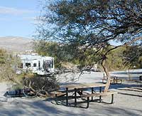
AGUA CALIENTE HOT SPRINGS
(San Diego County Park)
88 camp sites for tents & RVs, flush toilets, overnight / day use fees, 760-765-1188
located on Co. Rd S-2, 22 miles N of Interstate 8 (closed June-Aug)
BOX CANYON RDMecca, CA – in between Joshua Tree NP and Anza Borrego Desert
BLM camping in Box Canyon & Mecca Hills Wilderness Park
LEAPIN LIZARD RV RANCH
(Private Campground Resort)
85 acres, 60 camp sites
located on Split Mountain Road, Ocotillo Wells, CA
OCOTILLO WELLS SVRA
(State Vehicular Recreation Area)
elev. 160′, 4×4 and off road camp sites for trailers & RVs
no water, no hook-ups, pit toilets, no fees, 760-767-5391
located on Highway 78 (closed June-Sept)
PALM CANYON RV RESORT
(Private Campground Resort)
located in town, Borrego Springs, CA
SALTON SEA SRA
(State Recreation Area & Campground)
Mecca Beach, Corvina Beach, Salt Creek Campgrounds
located on Highway 111 on east side of inland sea
SLAB CITY @ SALTON SEA
old Camp Dunlap in California desert badlands
free & open RV camping near Salton Sea
located off Highway 111 on east side of inland sea
TRUCKHAVEN HILLS
(OHV trails & camp spots)
elev. 300′, 4×4 and off road camp sites for car camping, touy hauler trailers & RVs
no water, no hook-ups, no fees,
located on S-22, East of Borrego Springs, CA
VALLECITO PARK
(San Diego County Park)
44 camp sites for tents & RVs, no hook-ups, toilets, overnight / day use fees, 760-765-1188
located on S-2, 22 miles N of Interstate 8 (closed June-Aug)
FREE CAMPING ANZA– Let us also remind you that this is the best place to camp in California for primitive car camping (camping outside of a developed campground). Open all year long – always! Super secluded, darkest skies, free and always located on the back roads. 4×4 is not required in all areas, so there are plenty of options. Blair Valley or Coyote Canyon Gardens are popular camp spots, but there are thousands of hidden canyons and washes in this giant State Park, just awaiting your tent. You’ll need a decent topographic map. For more info on free camping click here.
San Diego Backcountry
600,000 acres of SoCal desert
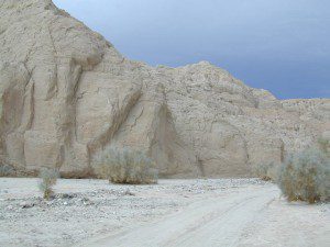
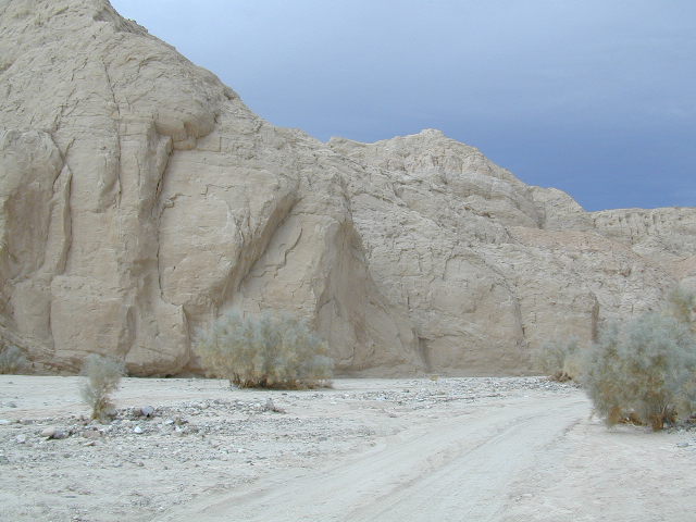
BLOOM: mid-March thru May Anza Park elevations range from low to high. Lowest near eastern border (next to the Salton Sea) to the upper reaches of the western slopes @ 4000′. Wide, deep, sandy, long desert washes, native petroglphs, wind caves, slot canyons and split mountain. This uncrowded state park has the most acreages than all of the parks.
OPEN CAMPING
Camp in a developed campground, a small back country site or camp primitive on nearly any dirt road. Car camping to 4×4, this park has lots to offer folks wishing to really escape. No ground fires allowed, so bring your metal campfire bucket and large trash bag to carry out your ashes. The last thing you want is to scar these pristine white desert washes.
DESERT WILDFLOWERS
Steep rocky canyons on the Laguna mountain foothills can be challenging terrain, so bring good, sturdy hiking boots. Wildflowers can be abundant on certain years. Lower elevations sprout up first; Higher elevations along County Rd S-2 & S-22 bloom later in Spring. By June 1st most of the color is gone in and around Borrego Springs, so this is a real Winter and Spring vacation kinda spot. California desert wildflowers include primrose, barrel cactus, prickly pear, monkey flower, ocotillo & many more.
This is the largest State Park in California and “open car camping” is allowed on the back roads. (also referred to as primitive camping, free camping or 4×4 camping) One of the few places in Southern California that you can camp outside of a developed Campground and still have a campfire. You gotta bring a large metal bucket to have your campfire in – as ashes scar white sandy washes and ground fires are not allowed.
California Highway 78 cuts across Southern California and right thru the middle of the largest State Park in the lower 48. Anza Borrego Desert State Park is a place that must be visited more than once to really take in all the beauty it has to offer. Free camping in Southern California is abundant here, if you are willing to follow the primitive camp fire rules of the park and you are comfortable camping away from developed campgrounds.
North-South:San Diego County Road S2 skirts the western border with Laguna Mountain towering above. It starts at Ocotillo @ Interstate 8 and heads Northwest to Lake Henshaw at Warner Springs.
East-West: a major route S22, connects Ranchita /Montezuma Valley to the Borrego Valley, and continues East to the Salton Sea. The center of the parks is pretty much the town of Borrego Springs, where the State Parks visitors center is located. San Diego County Road S3 leads from Hwy 78 down the the town of Borrego Springs Valley.
free camping: While the camping facilities listed above provide picnic tables and toilets, or more luxury camping… Total Escape thinks the best part of camping in Anza Borrego Desert is the vast amount of free, open camping available on most back roads. Hundreds of dirt roads lead off in all directions, so you can find the peace and solitude that few inside busy campgrounds ever experience.
Many Anza desert routes are sandy washes, dirt roads, some for high clearance vehicles only, or 4WD in several canyons. Often there is no signs telling you need 4×4 to proceed. May only find out when its too late and you’re stuck.
Have a good dirt road map with you and know your vehicles limitations. Passenger cars should be very cautious off road. Cell phone coverage is spotty out here in the most remote wilderness areas.
Saline Valley Hot Springs
Saline Valley Warm Springs
NORTH Death Valley National Park, in a super remote desert valley located in the vast mountains in between Big Pine CA Route 168 & Death Valley (west) Highway 190.
Inyo National Forest: Inyo mountains are a towering range of high elevation desert peaks running in between Owens Valley and Saline Valley.
desert wilderness access: 4 dirt road routes lead into Saline Valley – 2 backcountry 4×4 trails from the upper reaches of the park and 2 main dirt roads. All routes require a high elevation pass, so snow is likely in winter months (Nov-May).
Wilderness routes road conditions can change often, seasonally with winter snows, mud and summer thunderstorms. The most popular access are the main routes (both long dirt roads, subject to snow and closure at any time) – the North Pass (Big Pine) and the South Pass (Panamint). Detailed directions on those further below. Both backcountry roads Steele Pass and Lippincott Road, originate from the northern, desolate areas of the National Park and both require 4 wheel drive, with a recommended locking differential. No developed campground facilities. Clothing optional my ass — nudity is the norm here.
Since the challenging drive in to this remote desert valley is so grueling and time consuming, plan to spend a minimum of 4 nights. Anything less is way too rushed to totally enjoy the experience. Best way to enjoy this place is a full week off of work, and as much firewood, food and ice as you can haul. Some folks spend weeks camping here. The NPS limits your camping stay to 30 days! If you plan on driving out to Lone Pine for camping supplies and returning the same day, you best leave at dawn – cuz the entire round trip ‘beer run’ will take 6 hours or more.
High clearance vehicle a must & 4 wheel drive is highly recommended in all this region. All wheel drive wagons and passenger cars have been known to bottom out, break down and pop tires out here in the harsh conditions, so a first challenge may be to obtain a dependable and capable off-road vehicle.
Topographic GPS & decent back road maps are highly advised. One way drive is easily 4 hours, from any paved highway. Pack like you’re gonna live out here, if need be. Warning: this is a very long off-road journey for any average camping trip. This isn’t a weekend kinda place. First timers beware – it’s a full day journey to travel here!
Air Strip? The fly in option is a dirt landing strip called ‘Chicken Strip’, but National Park Service has yet to closed it.
NORTH PASS to Saline Valley Road:
from Big Pine, take Hwy 168 N from Hwy 395, turn right onto Death Valley Road (some maps may have this one listed as Waucoba Springs Road or just Waucoba Road). Proceed on the main route to the hard to read entrance sign marking the Saline Valley Road, past a few old structures and down to the main valley. Winter snow can be deep, so carry chains. 4×4 is best to access this remote valley, AWD high clearance might make it and normal passenger cars, 2WD SUVs should be warned about weather and access to the real world. Many times all mountain passes are snowed in – people do get trapped at Saline and cannot get out for weeks. So take that into account when requesting days off of work for this epic journey.
SOUTH PASS to Saline Valley Road:
from Olancha, take Highway 190 E, turn N off Hwy. 190 to Saline Valley Rd. Rugged 50+ mi. of hard core dirt roads. 4×4 and high clearance a must. Winter months expect snow, springtime rock slides and summers torrential downpours cause overflowing creeks w/ impassable washouts. Grapevine Canyon can be a challenging drive, but with patience and skill you can be down on the main valley floor in about an hour and a half (if you’re lucky). Did I mention the dozen or more miles of heavy washboard road conditions, at the base of the alluvial fan of mountain rock? Newbies and first timers should attempt the North Pass.
———————-
Near the marsh, when you finally reach the sand dunes area, you know the turn off is close-by, so slow down and stop to read the landscape. Know that the hot springs are located above the sand dunes to the east slope of the red volcanic mountains. When you see the metal bat sign and the mass of palm trees in the lower grove, you know you’ve arrived.
You’ve only truly arrived, when your whole body is immersed in hot water looking up at the stars and you learn to relax again. Breathe the deepest you have all year.
CAUTION: Stopping for those vehicles distressed on the side of the road is also a common practice. Many people break down on this route, Jeeps slide off cliffs. Harsh landscapes, plus weather are unforgiving and people die, so realize that this camping trip is no walk in the park.
Saline Valley Road Conditions & discussions can be found on Saline Valley Talk, the Saline Valley Message Board forum.salinepreservation.org
Since sport utility vehicles were invented for California yuppies, it makes perfect sense that this California market also has the awesome terrain to use these rugged rigs. After the first shopping cart door ding or windshield crack, most folks are open to taking their utilitarian vehicles on dirt roads, but some will only dream about it.
Here at Total Escape, we are here to change all that. The fear of outdoors, the unknown, the capability, the driving skill. Your SUV is a good reason to be outdoors in the golden state, at bare minimum. No excuses. Enjoy the California you never knew – and sometimes that means getting off the pavement. Yes, more than 2 miles.
SUV trail – any path, dirt road or route that can be driven on; high clearance vehicle are often necessary, 4×4 needed on occasion. National Forests, canyons, deserts, mountains, country lane style drives, some classic routes skirt the wilderness boundaries. We have it all for ya here. Rock crawling Rubicon adventures, all the way down to the leisurely ‘Sunday drive’ thru a forest to a meadow for a picnic.
MAPS will get you out there!
Dust, dirt, mud, snow. Beyond the county line, way back there, where you can discover ghost towns, old mines in the desert, hot springs, historic lodges, petroglyphs, river gorges, fire lookouts, waterfalls, and so much more.
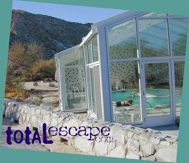
Agua Caliente Hot Springs County Park is a remote 910-acre San Diego County Park next to the Anza Borrego Desert. A developed hot springs, picnic area & a large campground. This desert destination is perfect for California winter recreation, offering a small air strip for small plane pilots.
Located North of Interstate 8 on San Diego Road S-2 on the south end of Anza-Borrego Desert State Park. Local mountain’s seismic forces created the fault that runs beneath this region & forces water up to the desert surface. A decent water supply also supports plant life & wildlife.
For minimal crowds AVOID THIS PLACE on holiday weekends or peak winter months. Spring & Autumn are excellent times to visit here, but watch the weather forecast for any heat waves. Who wants to soak when it’s 100 degrees outside?
2 natural hot mineral pools:
large outdoor pool is kept at natural 96 degrees
glass walled indoor pool is heated & has bubbling jets
spring-fed, warm showers are available
hiking trails, horseshoe & shuffleboard
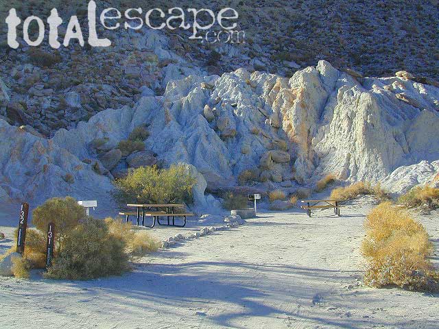
Agua Caliente Campground
140 campsites – tent sites & RV hookups w/ dump station. Shady trees only at some camp sites. Indoor pool, outdoor pools, maybe a hike-in primitive tub too. Individual campsites may be reserved up to 12 weeks in advance 858-565-3600
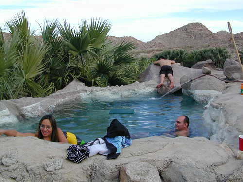
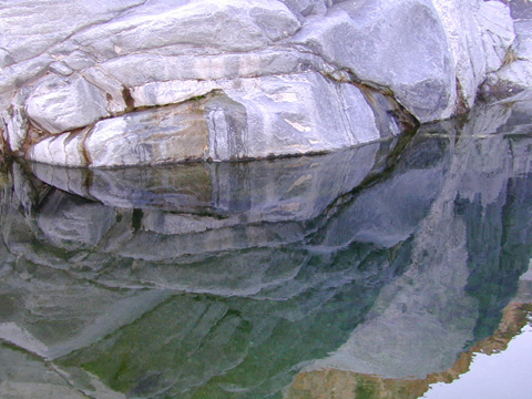
Off road destination, palm canyon in Baja California Norte
East of San Diego
SW of El Centro / Mexicali
Imagine a palm oasis canyon in a remote area of the Baja desert; Cool springs that feed the lush landscape with huge boulders & cliff diving waterfalls. With each campsite featuring it’s very own custom hot springs tub. This place was a paradise 20 years ago, but is now over-developed w/ large groups, parties and camping families. If you can handle the 30+ miles of unimproved dirt roads, this spot is worth a visit mid-week. Winter months are prime time to visit the desert. Temperatures are moderate, days are pleasant & midweek has minimal tourists. Avoid holiday weekends as crowds a can get rowdy and disrupt the peaceful setting. Summer is triple digit heat for months. This canyon is hard to reach and inside a third world country, but well worth the distant journey.
Plenty of great hiking and petroglyph canyons, cool pools and waterfalls, granite boulders, soothing warm waters & gorgeous desert scenery. Summers are usually roasting out here, so plan your vacation accordingly. Palalpas (built for shade) add to the charm & unique look. Each campsite is unique & has a different lay out. Reservations are recommended.
A family run set of campgrounds within a steep palm canyon. Hot Springs are piped to individual pools at each campsite for a maximum of privacy. A cold creek runs through the canyon as well, feeding the palm grove below & waterfalls way up canyon. A desert oasis set upon the slopes of the Sierra Juarez Mountains in Baja.
getting there is a journey –
Recommended high clearance vehicle, sport utility vehicle, or truck. The last 35 miles of the trip is through rough & rugged sandy roads.


 S2 Road intersects California SR 78 at Scissors Crossing and continues north through the barren San Felipe Hills. The Southern California portion of the Pacific Crest Trail parallels the ridge line on the east side, with the town of Borrego Springs lying behind that ridge at 590′ elevation. The historic mountain town of Julian sits in the hills above Banner Grade (Hwy 78).
 Hollywood & Vine
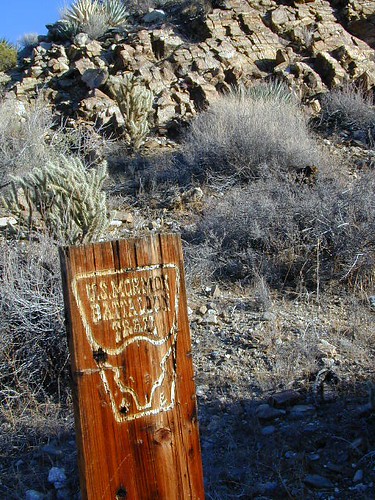


 . The center of the parks is pretty much the town of Borrego Springs, where the State Parks visitors center is located. San Diego County Road S3 leads from Hwy 78 down the the town of


 he desert surface. A decent water supply also supports plant life & wildlife.